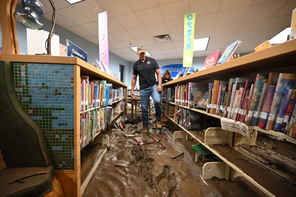
Gov. Wes Moore (D) inspects damage at a library in Westernport on May 15, 2025, in the wake of flooding in Western Maryland in the previous week. (Photo by Patrick Siebert/Governor's office)
Severe thunderstorms across Maryland on Thursday brought torrential rainfall reaching up to 6 inches in some areas, causing thousands to lose power and requiring several water rescues in Harford County after multiple cars were trapped by rising water.
Earlier this month, dozens of others had to be rescued from trapped cars in Montgomery and Fairfax counties after torrential rainfall in the Washington, D.C., area on July 19.
And in mid-May, flooding caused by days of heavy rain led to millions of dollars in damage and emergency response costs to several Western Maryland communities.
As the heat and humidity have increased in Maryland, so too has the number of flash floods. The state has had at least 51 flash flood warnings so far this year, its most since 2020, according to the National Weather Service. Maryland had 45 warnings throughout all of 2024.
Chris Strong, the warning coordination meteorologist for the NWS Baltimore-Washington office, attributed the increase to the abnormally hot and humid conditions, especially over the past six weeks. Flash floods typically occur in the early summer months from about June to August, he said.
“We haven’t had a lot of extreme heat days where it’s been over 100 degrees, but we’ve had a lot of very warm days, and, more importantly for the flash flooding, a lot of very humid days,” Strong said.
James Hyde, manager of the Maryland Mesonet, a growing network of weather-monitoring stations across the state run through the University of Maryland, College Park, said there is a higher amount of precipitable water in the atmosphere, which he described as “if you took all the water in the air above your head” and squished it down into a cup and then measured the amount.
Normally, Hyde said, precipitable water ranges from about 1.3 to 1.4 inches during this time of year. But during the thunderstorms this summer, the amount has ranged from 1.8 to 2.3 inches, which is up to a 75% increase.
Water is one of the most powerful forces there is. In terms of direct fatalities, nothing’s a bigger weather killer than flooding is. So anytime there’s flash flood warnings in particular for your area, people’s awareness should be heightened as to what the water is doing around them.
– Chris Strong, warning coordination meteorologist, National Weather Service
The combination of high humidity and temperatures in the lower atmosphere and weak wind flow in the upper atmosphere has led to slow-moving thunderstorms producing heavy rainfall — the perfect recipe for flash flooding, Hyde said.
“They tend to sit and dump rain,” he said. “That’s when you start to get the flash flooding scenarios. The soils quickly become saturated, it goes into surface runoff, etc.”
First came drought
The increase in flooding this summer comes after a roughly two-year long period of drought in Maryland, according to the Chesapeake Bay Foundation’s restoration specialist Rob Schnabel.
A year ago, about two-thirds of the state was classified as abnormally dry, while almost a quarter was in severe drought, according to the U.S. Drought Monitor. On Thursday, only 3% of the state’s land was classified as abnormally dry.
Schnabel said that as the climate changes, the state is seeing these periods of drought followed by large, sudden rainfalls.
“Once the soil is really dried out, and kind of baked somewhat with the heat temperatures, it actually has less ability for water to infiltrate into the ground,” he said. “Healthy soil is 25% air, 25% water and then the rest is solid material. But once you bake the ground and lose that water vapor in the ground, you lose that sponge effect.”
When there are these kinds of heavy rainfalls after two years of drought, he said, some of the soil “might as well be pavement.”
Another key issue, Schnabel added, is Maryland’s lack of stormwater management as continued urban development leads to more impervious surfaces, like parking lots or roadways, which can’t soak up water and instead create more runoff.
To combat the issue, communities can utilize multiple strategies such as planting more trees, which can absorb up to 13,000 gallons of water a year each, or creating rain gardens in natural drainage areas in parking lots, he said.
“We really need to focus more on water volume,” he said. “What happens on the land is going to determine the whole success of the Chesapeake Bay cleanup. So we need to do a better job of addressing water up on the land prior to it coming into our stream systems and into the bay.”
More floods, more collaboration
The increased flooding has caused damage to several communities across the state so far this year, including many in Western Maryland.
From May 12 to 14, “extreme rainfall” triggered significant flooding which inundated several communities in Garrett and Allegany counties. According to official estimates, the floods caused $15.8 million in emergency response costs and damage to local infrastructure — including 200 homes.
Last month, the Federal Emergency Management Agency denied the state’s request for emergency assistance funds. Speaking to reporters in Westernport on Sunday, Gov. Wes Moore (D) called the denial a “political decision” by President Donald Trump (R), and criticized it as petty, partisan and punishing.
But as the state faces more and more floods, Hyde said he has “never seen more collaboration” among weather analysts, state emergency management officials and those who run the warning systems.
“People behind the scenes are watching this and paying attention,” he said. “The Mesonet takes observations every three seconds, and we’re transmitting that data every minute.”
One strategy counties are employing to combat the danger of flash flooding, Strong said, is to purchase properties that are at particular risk for flash floods so there’s less exposure to the public when one occurs.
And as the state’s weather monitoring systems improve, Strong said the goal is to increase the time between when a warning is issued and when actual flooding occurs. Currently, he said the average is about an hour before a flood occurs that a warning is sent out.
He emphasized the danger that flash floods pose, particularly for low-lying areas where water drains to.
“Water is one of the most powerful forces there is,” he said. “In terms of direct fatalities, nothing’s a bigger weather killer than flooding is. So anytime there’s flash flood warnings in particular for your area, people’s awareness should be heightened as to what the water is doing around them.”


Comments