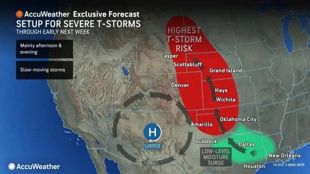
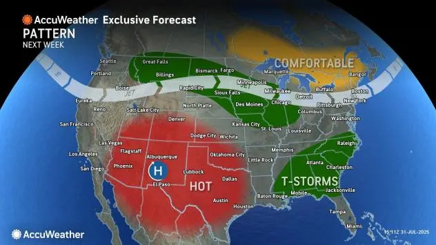
As cool, less humid air settles from the Midwest to the Northeast, heat will build over the western United States from Interstate 5 to Interstate 25. In between, weather warfare will rage as severe thunderstorms erupt on a daily basis through this weekend and into early next week in a zone just east of the Rocky Mountains, known as the High Plains.
A heat dome associated with high pressure extending from ground level to miles high into the atmosphere will help create the stormy pattern for some and sustain it into next week.
The main threats from the storms will be for pockets of damaging wind gusts and hail that could damage crops and property. As the storms erupt during the late afternoon and evening hours, frequent lightning strikes can occur, as well as highly localized flash flooding. A small number of the strongest storms may also spawn a tornado.
The risk of severe weather will roughly cover the same area for multiple days in a row with some fluctuation from day to day.
Motorists using U.S. Routes 83, 287 and 385 and Interstate 25, which run north and south over much of the Plains, may encounter delays and dangerous conditions in some areas, especially during the late afternoon and evening hours. The same risks will apply to west-to-east highways that bisect the region, such as Interstates 20, 40, 70, 80, 90 and 94.
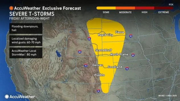
Into Friday night, the likelihood of some severe thunderstorm activity will extend from northeastern New Mexico to southeastern Montana and southwestern North Dakota.
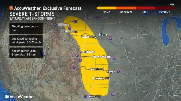
From Saturday afternoon to Saturday night, areas from the Texas Panhandle to central Montana will be at risk for severe thunderstorms. While not every location within this zone will be blasted by severe weather, the few storms that erupt can be intense for a brief time. The AccuWeather Local StormMax™ wind gust for Saturday's storms is 85 mph.
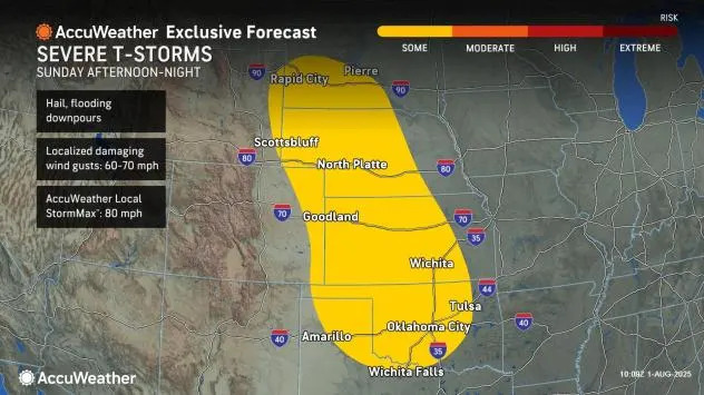
The risk of severe weather on Sunday afternoon and night will focus a bit farther to the east over the Plains states but will still have considerable overlap with Saturday's storms.
The severe weather threat for the latter part of the weekend will extend from north-central and northwestern Texas, as well as central and western Oklahoma to much of western and central South Dakota, as well as eastern Wyoming.
The zone from Texas to parts of the Dakotas will remain active in terms of thunderstorms during the early days of the new week, with more severe weather anticipated.
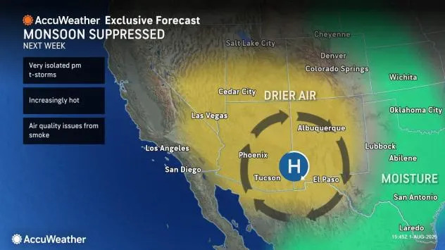
As high pressure strengthens over part of the Southwest into the Rocky Mountains next week, it will suppress the thunderstorms associated with the North American monsoon.
As the heat dome strengthens, mountain valley locations such as Ruidoso, New Mexico, which has been blasted with multiple flash flooding events this summer, should catch a break.
On the northern rim of the heat dome, from Washington to northern Idaho, Montana and the Dakotas, there will be the potential for large, fast-moving complexes of severe thunderstorms with high winds to unfold next week.
Additionally, rounds of wind conditions will raise the risk of wildfire ignition and spread over the Northwest to parts of the Rockies next week.
Temperatures will throttle up and may exceed 10 degrees over historical averages from Arizona, Nevada and Utah into Texas and Oklahoma next week. This could put some daily record highs in jeopardy in places such as Phoenix, Denver, Las Vegas and Salt Lake City. At the very least, temperatures will come within a few degrees of records.
Want next-level safety, ad-free? Unlock advanced, hyperlocal severe weather alerts when you subscribe to Premium+ on the AccuWeather app. AccuWeather Alerts™ are prompted by our expert meteorologists who monitor and analyze dangerous weather risks 24/7 to keep you and your family safer.


Comments