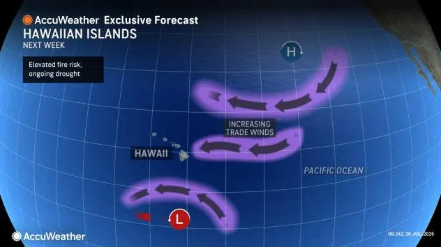
AccuWeather hurricane experts are monitoring several areas across both the central and eastern Pacific basins including an area well south of Hawaii which can increase the wildfire risk across the island chain next week.
A cluster of showers and thunderstorms well southeast of Hawaii is expected to continue to gain intensity into early next week. In turn, there is a high risk for development into a tropical depression or storm in the coming days. The first name on the list for tropical storms that form in the Central Pacific in 2025 is Iona.
Any development that occurs is expected to likely stay well south of Hawaii. While no direct impacts are expected to the Hawaiian Islands, the budding tropical development will work with an expansive area of high pressure to the north of the islands increasing trade winds.

"Gusty trade winds can start to pick up across the Hawaiian Islands on Tuesday and can last through the end of the week and into the start of next weekend, said AccuWeather Lead Hurricane Expert Alex DaSilva.
The increased trade winds combined with moderate or greater drought conditions across over half of the Hawaiian Islands will heighten the wildfire risk through majority of next week. The dry grass and vegetation will provide plenty of fuel for any fire that sparks.
Have the app? Unlock AccuWeather Alerts™ with Premium+
"While this setup is not the same as the one that allowed the Maui wildfires to rapidly spread, high wildfire danger can still exist across the islands next week," adds DaSilva.
Elsewhere across the Pacific
On the heels of the high risk southeast of Hawaii another area southeast of the island chain is being monitored for development at the end of the weekend towards early next week. Any development would likely be short-lived and not have any impact to land.
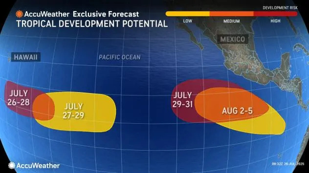
Farther to the east, AccuWeather hurricane experts are monitoring two additional areas for tropical development southwest of Mexico including a high risk for tropical development to end July. Any development from either area late July into August could bring impacts to Mexico as well as impact any shipping interests.
Remaining quiet in the Atlantic through early week
Unlike the central and eastern Pacific basins, the Atlantic basin will be quiet through early next week. The combination of dry air and disruptive breezes (wind shear) will inhibit any tropical activity across the basin.
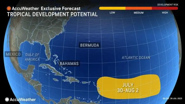
The quiet stretch won't last for long as a tropical wave moving westward from Africa has a low risk for development as it approaches the Lesser Antilles mid to late next week. Regardless of development, there can be an increase in thunderstorm activity across the Lesser Antilles by next weekend.
Want next-level safety, ad-free? Unlock advanced, hyperlocal severe weather alerts when you subscribe to Premium+ on the AccuWeather app. AccuWeather Alerts™ are prompted by our expert meteorologists who monitor and analyze dangerous weather risks 24/7 to keep you and your family safer.


Comments