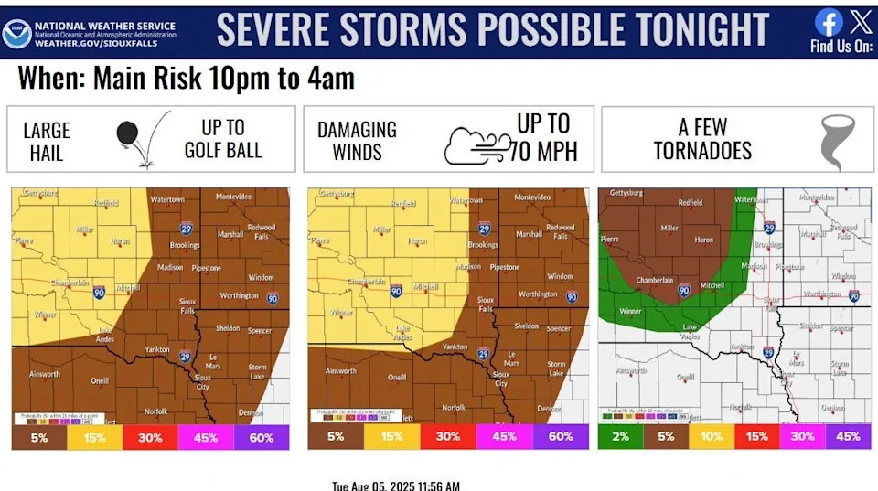
Severe storms are possible throughout southeastern South Dakota, northeastern Nebraska, northwest Iowa and southwest Minnesota from 10 p.m. Aug. 5 to 4 a.m. Aug. 6.
The National Weather Service in Sioux Falls is predicting large hail up to golf ball size, damaging winds up to 70 miles per hour, and a few tornadoes possible during this time frame.
These scattered storms may form into a line and track southeast over that period of time and lead to locally heavy rain, the NWS reported.
NWS officials suggest residents have multiple ways to receive warnings for storms, including from local TV stations, weather apps, websites, radio and weather radio. They also suggest knowing one’s shelter and staying weather aware if residents have outdoor plans.
Forecast details
Here’s a more detailed forecast from the National Weather Service for the Sioux Falls area.
Wednesday: A 40% chance of showers and thunderstorms, mainly before 7 a.m. Mostly sunny, with a high near 85. South wind 10 to 15 mph, with gusts as high as 20 mph.
Wednesday night: A 20 percent chance of showers and thunderstorms. Partly cloudy, with a low around 70. South southeast wind 5 to 10 mph.
Thursday: Sunny, with a high near 88. South southeast wind 5 to 10 mph, with gusts as high as 20 mph. Thursday night will be partly cloudy, with a low around 73. South southeast wind around 10 mph, with gusts as high as 20 mph.
Friday will be mostly sunny, with a high near 91. At night, there’s a 30% chance of showers and thunderstorms after 1 a.m. Mostly cloudy, with a low around 69.
Saturday will be partly sunny, with a high near 84. At night, there’s a 30% chance of showers and thunderstorms before 1 a.m. Partly cloudy, with a low around 63.
Sunday will be mostly sunny, with a high near 84. At night, it’ll be partly cloudy, with a low around 62.
Monday will be mostly sunny, with a high near 84.
This article originally appeared on Sioux Falls Argus Leader: NWS predicts severe overnight thunderstorms in Sioux Falls area


Comments