SALT LAKE CITY (ABC4) – Happy Wednesday, Utah! Another day of critical fire danger and an elevated fire risk. Hot, dry and windy conditions will stick around as we make it through today and most of our work week.
The bottom line? Very dry conditions into the midweek with an elevated fire threat for most of Utah’s mountains
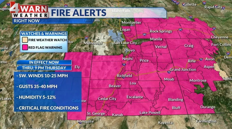
We are underneath a mild and dry Southwest flow, with gusty southwest winds in parts of the state. These winds are a key player in our continued fire danger. Red Flag Warnings are in effect for the Eastern Uinta Basin, Book Cliffs, Color Country Mountains, and the Central Mountains, where the Monroe Canyon Fire is burning, will hold onto theirs until tonight at 9 p.m.
The rest of the alerts, including places like Grand Staircase, the Southwest & Central West Desert, San Rafael Swell, and the Mojave Desert, will expire Thursday night. Southwest winds of 10-25 mph with gusts ranging from 30-40 mph are on deck. Relative humidity will fall as low as 4-12% in the impacted areas. We could see some of the alerts get extended and possibly linger into the close of the work week.
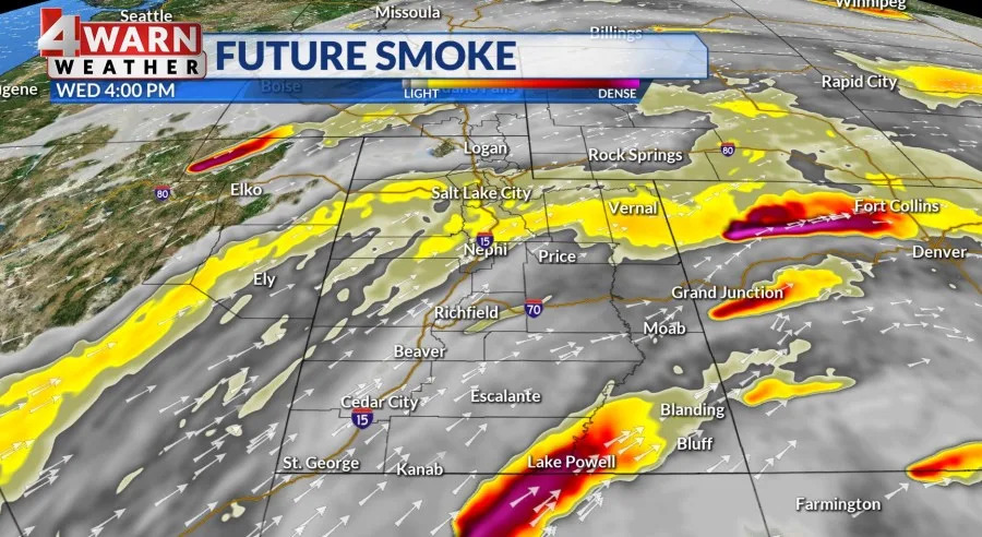
While we have mostly sunny skies ahead, periods of haze and smoke will plague the entire state. We’re seeing wildfire smoke throughout the West. Our southwest flow is ushering smoke from around the region into Utah, including fires burning in Southern California, Arizona and right here in Utah. Moderate air is expected in counties where air is monitored, but we could see unhealthy air pop up in certain counties where air is monitored.
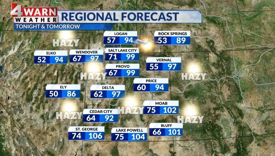
As far as temperatures go, daytime highs will run in the upper 90s for most valleys, mid-80s to low-90s for higher terrain, and low to mid-100s for hot spots like St. George. Several locations along the Wasatch Front will flirt with triple digits today and tomorrow, and by the end of the work week, a dry cold front will pass through the region and knock our highs a few degrees below average. We could see a day or two in the upper 80s, which would be a nice change from the summer heat. As far as wet weather goes, we don’t have any in the forecast.
Dry conditions statewide with worsening drought conditions are expected, with long-range weather models suggesting we don’t see precipitation through mid-month. Yikes!
We will see how the weather pattern shapes up, so we’ll keep you updated on the latest developments in our 4Warn Weather forecast both on-air and online we are Good4Utah!
Copyright 2025 Nexstar Media, Inc. All rights reserved. This material may not be published, broadcast, rewritten, or redistributed.
For the latest news, weather, sports, and streaming video, head to ABC4 Utah.


Comments