Rising threat of 'significant storms' in Minnesota Friday, with 80 mph winds possible originally appeared on Bring Me The News.
The threat of severe weather in Minnesota over the coming days is rising, with officials warning of the potential for "significant" severe storms as the weekend approaches.
The National Weather Service says there is a risk of thunderstorms on Wednesday evening and severe storms on late Thursday, but the biggest risk appears to arrive on Friday.
The NWS Grand Forks says Friday could bring "significant severe weather with all hazards possible."
"Environmental conditions would favor storms that do develop capable of hail over 2 inches, winds 80 mph and potential for tornado development," it said.
The biggest threat as things stand is in west-central and northwestern Minnesota, which are in the "enhanced" risk zone for severe weather on Friday afternoon and evening.
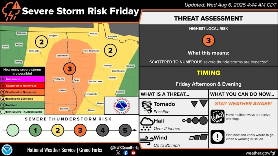
Central, southwestern and north-central Minnesota are in the "slight" risk zone as the system is expected to move into Minnesota from the Dakotas.
The Twin Cities has lower chances of severe weather, with the threat currently "marginal" as of Wednesday morning. However, the NWS notes in its forecast discussion that the potential for "broad instability" could push storms further east into the state.
The threat of storms on Thursday and Friday will come on the back of rising heat in Minnesota, with the combination of air temperatures close to 90F and high humidity potentially pushing the heat index into the 100-105 rang eby Friday.
It's possible that an extreme heat warning is issued across much of Minnesota, including the Twin Cities.
This story was originally reported by Bring Me The News on Aug 6, 2025, where it first appeared.


Comments