The busiest period of the Atlantic hurricane season runs from mid-August through mid-October and this month is living up to that reputation.
The National Hurricane Center is tracking three systems in the tropics: Tropical Storm Dexter, Invest 96L and a weak area of low pressure off the southeastern coast of the United States.
➤ Weather alerts via text: Sign up to get updates about current storms and weather events by location
Dexter is expected to reach hurricane strength within the next 24 hours, and Invest 96L could form into a tropical depression late this weekend or early next week.
AccuWeather forecasters also are highlighting several areas showing potential for tropical development into mid-August, including one in the Gulf.
The next named storms of the Atlantic hurricane season will be Erin and Fernand. The fifth-named storm of the season historically develops Aug. 22, followed by the sixth-named storm on Aug. 29, according to AccuWeather.
Here's the latest advisory from the National Hurricane Center as of 8 a.m., Aug. 7:
Where is Tropical Storm Dexter and where is it going?
Location: 425 miles south of Cape Race, Newfoundland
Maximum sustained winds: 50 mph
Movement: east-northeast at 18 mph
Pressure: 998 mb
Next advisory: 11 a.m.
➤ Tropical Storm Dexter: See latest spaghetti models, any Florida impacts
Spaghetti models for Tropical Storm Dexter
Special note about spaghetti models: Illustrations include an array of forecast tools and models, and not all are created equal. The hurricane center uses only the top four or five highest performing models to help make its forecasts.
Where is Invest 96L and where is it going?
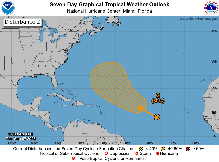
Invest 96L is a tropical wave in the central Atlantic moving west-northwest.
It could become a tropical depression late this weekend, Aug. 9-10.
Spaghetti models for Invest 96L
Special note about spaghetti models: Illustrations include an array of forecast tools and models, and not all are created equal. The hurricane center uses only the top four or five highest performing models to help make its forecasts.
Will Dexter become a hurricane?
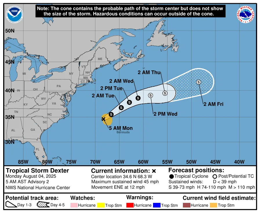
Dexter is expected to continue strengthening and is expected to reach hurricane strength with 75-mph winds over the next 24 hours.
➤ How often has Florida been impacted, threatened by August hurricanes? We took a look back
What tropical waves, disturbances are in Atlantic basin now? How likely are they to strengthen?
First tropical wave: A weak area of low pressure located a couple of hundred miles off the coast of the southeastern United States is producing minimal shower and thunderstorm activity. Some slow tropical or subtropical development is possible over the weekend while the system moves northward to northeastward, remaining well off the east coast of the United States. By early next week, the low is expected to becomeextratropical, ending its chances for tropical development.
Formation chance through 48 hours: low, near 0 percent.
Formation chance through seven days: low, 30 percent.
Second tropical wave: A tropical wave, now classified as Invest 96L, over the central tropical Atlantic is producing disorganized shower activity. Environmental conditions are forecast to become more conducive for gradual development in a few days, and a tropical depression could form late this weekend or early next week while the system moves west-northwestward to northwestward across the central tropical and subtropical Atlantic.
Formation chance through 48 hours: low, 10 percent.
Formation chance through seven days: medium, 60 percent.
How could disturbance off southeast coast affect Florida?
"This system poses no direct threat to Florida at this time," the Florida Department of Emergency Management said.
None of the systems out there "pose any threat to land through at least early next week," the National Hurricane Center posted on X.
"Even though the center of the budding storm will likely stay offshore, slow movement and proximity to the Carolina coast would still result in some downpours and wind in that region from late this week to the start of the weekend," AccuWeather Lead Hurricane Expert Alex DaSilva said.
Is there a hurricane coming toward Florida?
No, but remember conditions can change rapidly.
The busiest period of the hurricane season runs from mid-August through mid-October and activity is picking up.
The system off the southeastern coast could bring increased chances for rain, especially for the Carolina coast, along with rought surf and rip currents.
Besides the systems currently being tracked by the National Hurricane Center, AccuWeather forecasters also are keeping an eye on several other tropical waves, including one expected to move into the Gulf later this weekend or early next week.
What do the colored, hatched areas on the NOAA map mean?
The hatched areas on the National Hurricane Center's tropical outlook map indicate "areas where a tropical cyclone — which could be a tropical depression, tropical storm or hurricane — could develop," said National Hurricane Center Deputy Director Jamie Rhome.
The colors make it visibly clear how likely a system could develop, with yellow being low, orange medium, and red high.
The National Hurricane Center generally doesn't issue tropical advisories until there is a named storm, but there is an exception.
"If a system is near land and there is potential for development, the National Hurricane Center won't wait before it issues advisories, even if the system hasn't become an actual storm. This gives residents time to prepare," Rhome said.
What should you do now to prepare for hurricane season?
Officials regularly encourage Florida residents to prepare for storms before a hurricane is approaching while shelves are full stocked and you aren't battling crowds all rushing to the store at the same time.
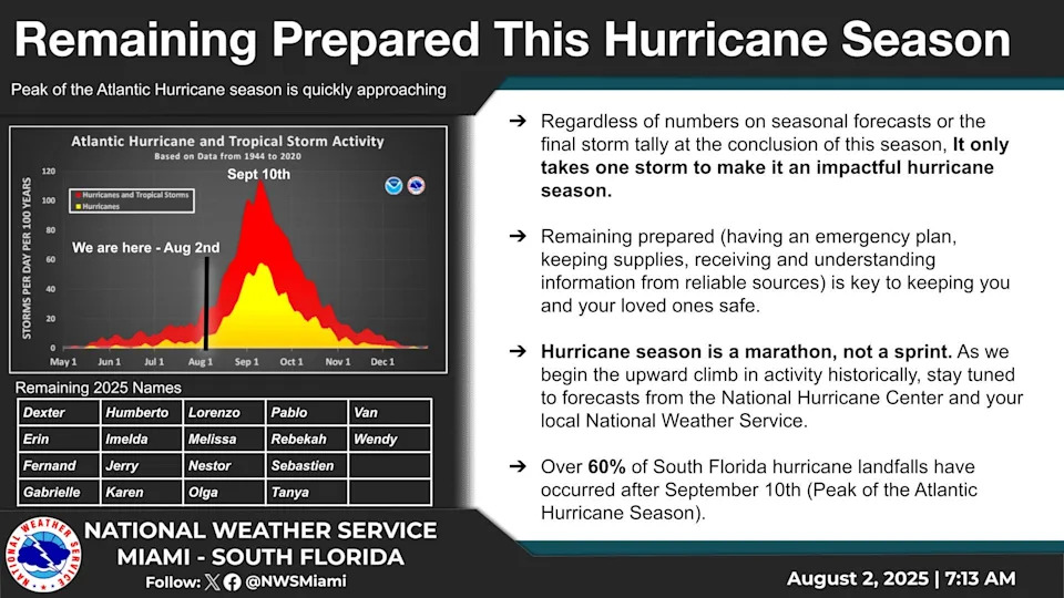
"It only takes one storm to make it an impactful year for your community," the National Hurricane Center Miami posted on X. "Hurricane season is a marathon, not a sprint."
On Aug. 1, specific hurricane supplies became permanently tax free in Florida, ranging from batteries to generators.
➤ See list of emergency supplies you can now buy tax free
Florida weather radar for Aug. 7, 2025
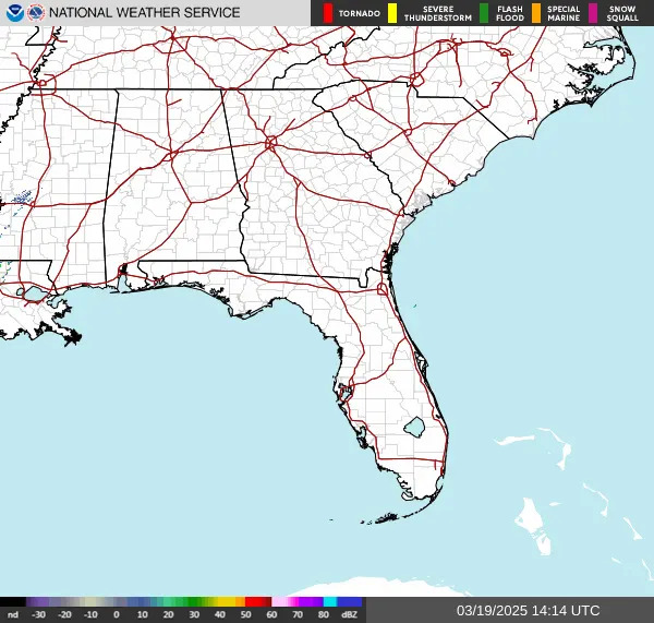
Weather watches and warnings issued in Florida
When is the Atlantic hurricane season?
The Atlantic hurricane season runs from June 1 through Nov. 30.
Ninety-seven percent of tropical cyclone activity occurs during this time period, NOAA said.
The Atlantic basin includes the northern Atlantic Ocean, Caribbean Sea and Gulf of America, as the Gulf of Mexico is now known in the U.S. per an order from President Trump. NOAA and the National Hurricane Center are now using Gulf of America on its maps and in its advisories.
When is the peak of hurricane season?
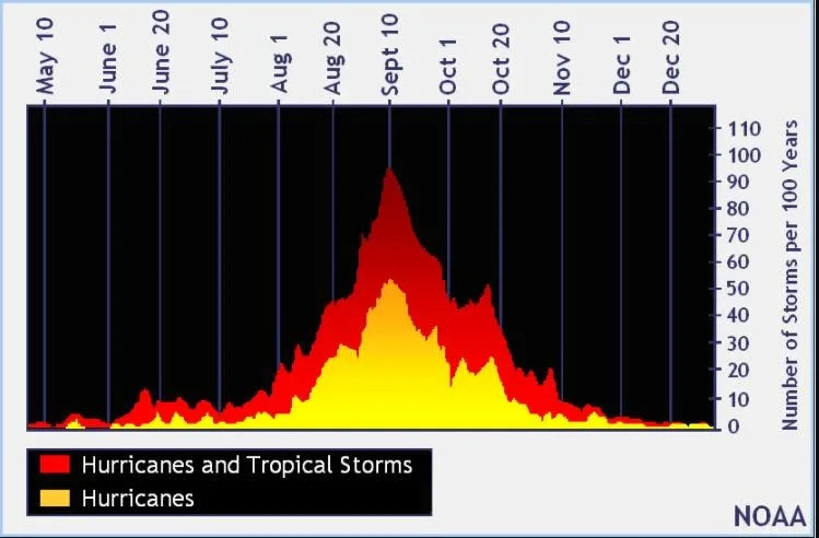
The peak of the season is Sept. 10, with the most activity happening between mid-August and mid-October, according to the Hurricane Center.
Hurricane names for 2025 season
Here are the names for the 2025 Atlantic hurricane season, along with how to pronounce them:
Andrea(June 20)Barry(June 29)Chantal(July 5)Dexter: DEHK-ster (Aug. 3)
Erin: AIR-rin
Fernand: fair-NAHN
Gabrielle: ga-bree-ELL
Humberto: oom-BAIR-toh
Imelda: ee-MEHL-dah
Jerry: JEHR-ee
Karen: KAIR-ren
Lorenzo: loh-REN-zoh
Melissa: meh-LIH-suh
Nestor: NES-tor
Olga: OAL-guh
Pablo: PAHB-lo
Rebekah: reh-BEH-kuh
Sebastien: se-BAS-tee-en
Tanya: TAHN-yuh
Van: van
Wendy: WEN-dee
National Hurricane Center map: See what forecasters watching now
Systems currently being monitored by the National Hurricane Center include:
Interactive map: Hurricanes, tropical storms that have passed near your city
Stay informed. Get weather alerts via text
What's next?
We will update our tropical weather coverage daily.
Download your local site's app to ensure you're always connected to the news. And look for our special subscription offers here.
This article originally appeared on Florida Times-Union: NOAA Hurricane Center tracking Dexter, Invest 96L Spaghetti models


Comments