Tropical Storm Erin is expected to begin strengthening soon and is likely to become a hurricane in the next 48 hours, according to the latest advisory from the National Hurricane Center.
Erin is moving fast across the Atlantic, at 22 mph. It's forecast not only to become the Atlantic season's first hurricane, but also a major hurricane. A major hurricane is one that's a Category 3 or higher, with maximum sustained winds of at least 111 mph.
➤ Weather alerts via text: Sign up to get updates about current storms and weather events by location
It's too early at this time to determine whether Erin will have any impacts on Florida or the United States, according to the National Hurricane Center and Florida Division of Emergency Management. Officials encourage residents to monitor Erin closely and to be prepared.
The fifth-named storm of the Atlantic hurricane season, Erin formed earlier than the historical average of Aug. 22.
The average date for the first hurricane is Aug. 11, and the first major hurricane typically does not occur until Sept. 1, according to AccuWeather.
Highlights on what Tropical Storm Erin is doing now
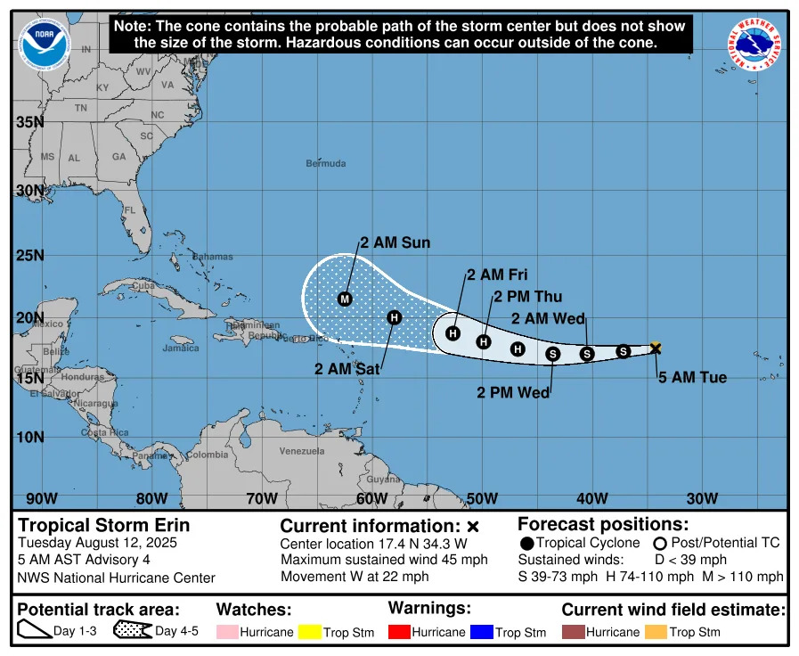
Special note on the NHC cone: The forecast track shows the most likely path of the center of the storm. It does not illustrate the full width of the storm or its impacts, and the center of the storm is likely to travel outside the cone up to 33% of the time.
Location: 690 miles west of the Cabo Verde Islands; 1,890 miles east of the northern Leeward Islands
Maximum sustained winds: 45 mph
Movement: west at 22 mph
Pressure: 1,004 mb
Next advisory: 11 a.m. ET
Tropical Storm Erin: What you need to know
At 5 a.m., the center of Tropical Storm Erin was located near latitude 17.4 North, longitude 34.3 West. Erin is moving toward the west near 22 mph, and this motion is expected to continue for the next several days with a decrease in forward speed and a gradual turn toward the west-northwest.
Maximum sustained winds are near 45 mph, with higher gusts. Tropical-storm-force winds extend outward up to 45 miles from the center.
Gradual strengthening is forecast over the next several days, and Erin is expected to become a hurricane in the next couple of days.
Spaghetti models for Tropical Storm Erin
Special note about spaghetti models: Illustrations include an array of forecast tools and models, and not all are created equal. The hurricane center uses only the top four or five highest performing models to help make its forecasts.
Is there a hurricane coming toward Florida? Expected impacts from Tropical Storm Erin
No tropical storm — or hurricane — watches or warnings have been issued for Florida or the United States, and it's too early to tell whether Erin will impact the U.S., according to the National Hurricane Center, National Weather Service and Florida Division of Emergency Management.
Even if Erin does avoid a landfall in Florida, "there will be a significant increase in seas, surf and rip currents along the East Coast beaches next weekend into the following week," said AccuWeather Senior Meteorologist Chad Merrill.
"Dangerous conditions may develop in Bermuda and parts of the Bahamas, as well."
How strong is Tropical Storm Erin and where could it go? See the scenarios
Several factors favor the strengthening of Tropical Storm Erin, including a lack of dust and wind shear, along with warm water temperatures, according to AccuWeather.
As Erin moves west across the Atlantic, it's expected — at this time — to begin a curve to the north Thursday or Friday, keeping the main part of the storm north of the islands in the northeastern Caribbean. However, depending on Erin's exact track, Puerto Rico and Hispaniola could get some rough surf and perhaps squalls.
"Erin will be guided along by the northeast trade winds initially and then the clockwise circulation around the massive Bermuda High over the central Atlantic," AccuWeather Lead Hurricane Expert Alex DaSilva said.
"It is the shape of that oceanic high, as well as the approach of a cool front and dip in the jet stream near the Atlantic Coast, that will determine the exact track of the projected major hurricane as it approaches the Atlantic Coast of the United States next week."
The scenarios, according to AccuWeather are:
"If the Bermuda High remains fairly round or yields to the approaching cool front and jet stream dip, Erin is likely to turn to the north before reaching the U.S.
"If the Bermuda High extends well to the west, it could block the potential major hurricane's northward path. The result would be a potential track very close to or onshore in the U.S., probably somewhere from the Carolinas north."
Key messages from the National Hurricane Center: What you need to know about Tropical Storm Erin
Erin has not become significantly better organized overnight.
The tropical storm continues to move quickly to the west.
Strengthening is expected as Tropical Storm Erin enters an area of low wind shear and increasingly warm water temperatures.
Erin is expected to become a major hurricane in about five days, although "there is significant uncertainty in intensity predictions" at this time.
It is too early to determine what impacts, if any, Erin may bring to the northern Leeward Islands, Bermuda, or the east coast of the United States.
Current forecast: How strong could Tropical Storm Erin get?
At 5 a.m.: 45 mph
12 hours: 50 mph
24 hours: 60 mph
36 hours: 65 mph
48 hours: 75 mph
60 hours: 85 mph
72 hours: 100 mph
96 hours: 110 mph
120 hours: 115 mph
What impact could Tropical Storm Erin have and what areas could be affected?
It's still early to tell yet what impacts Tropical Storm Erin could have on Florida or the United States, although forecasters said rough surf and dangerous rip currents are possible along the east coast as Erin approaches.
Officials warn residents should be prepared and closely monitor the storm that's expected to become a major hurricane later this week.
Interactive map: What tropical storms, hurricanes have impacted your area in the past?
Stay informed. Get weather alerts via text
What's next?
We will update our tropical weather coverage daily.
Download your local site's app to ensure you're always connected to the news. And look for our special subscription offers here.
This article originally appeared on Naples Daily News: Tropical Storm Erin: See track, spaghetti models, Florida impact


Comments