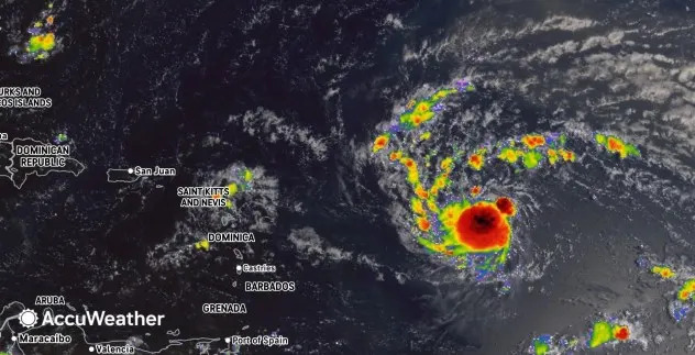
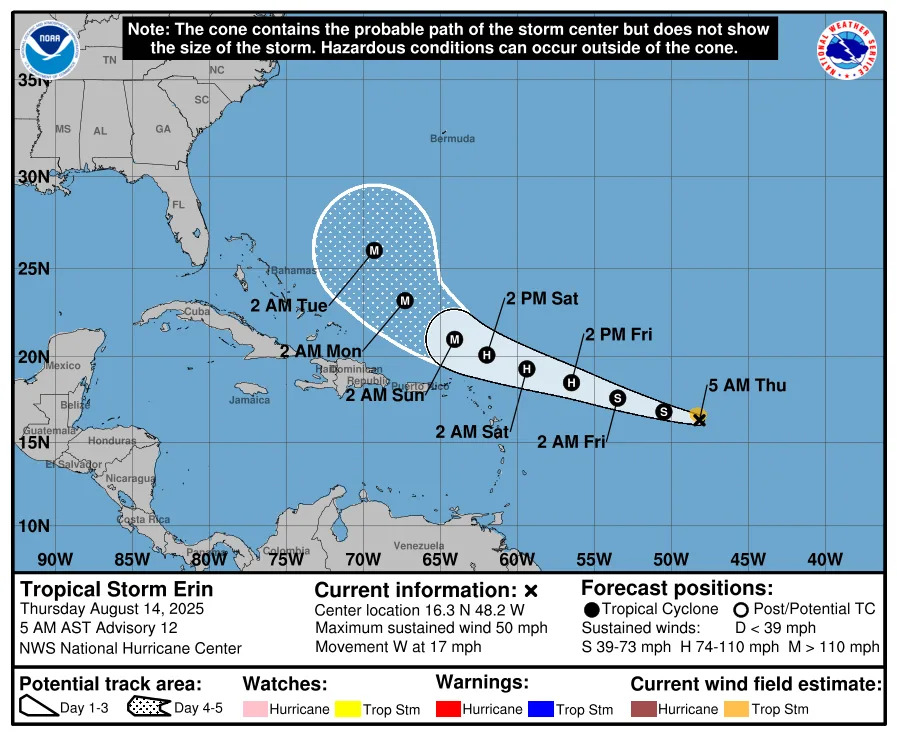
Tropical Storm Erin is expected to strengthen into a powerful hurricane and could bring heavy rain, damaging winds and dangerous surf to the Leeward Islands and Puerto Rico this weekend. AccuWeather meteorologists say a turn toward the west-northwest is likely before Erin reaches the islands. However, if that turn occurs later than expected, the threat of more significant impacts-including flooding and damaging wind-will increase.
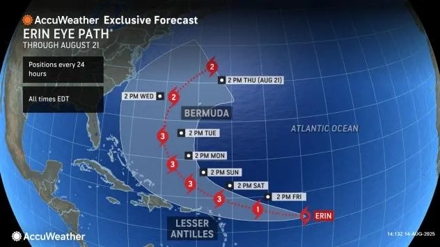
"Erin is expected to strengthen and become a hurricane by Friday," AccuWeather Lead Hurricane Expert Alex DaSilva said. "Atmospheric and oceanic conditions northeast of the Lesser Antilles will favor additional and rapid strengthening, with Erin to become a major Category 3 hurricane on Saturday."
There is a window of opportunity for Erin to rapidly intensify into a Category 4 hurricane this weekend or early next week.
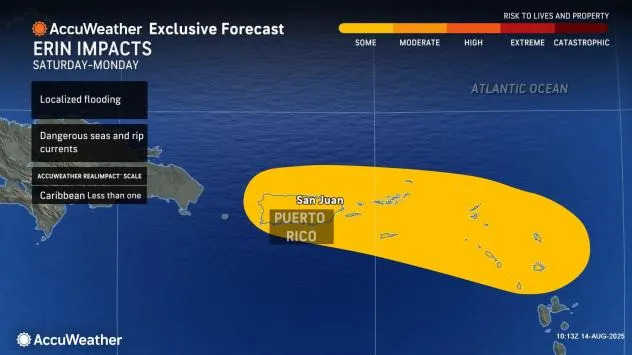
As Erin strengthens, its wind field, heavy rain and thunderstorm activity will expand, covering a larger area. According to the AccuWeather RealImpact™ Scale for Hurricanes, the projected impact on the northern Caribbean currently rates less than one.
Bands of rain may produce torrential downpours and gusty winds, even though the eye of the storm is expected to pass north of the Leeward Islands and Puerto Rico.
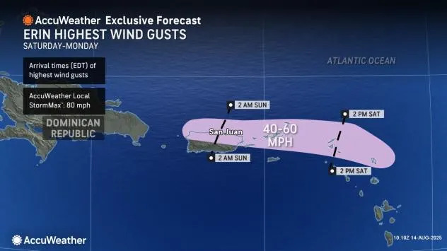
"Many of these bands may occur as the core of the storm has passed or is moving away," AccuWeather Senior Meteorologist Adam Douty said. The AccuWeather Local StormMax™ for rainfall in the northern Caribbean is 7 inches.
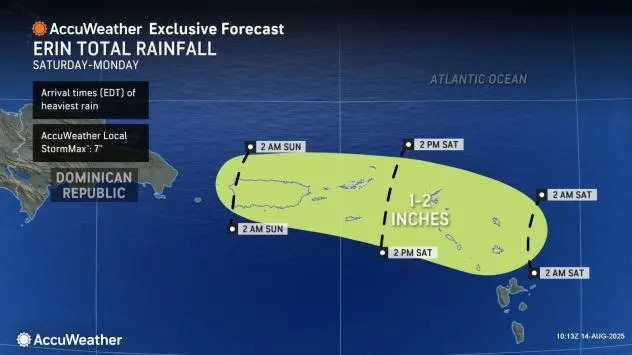
Areas where squalls persist or repeat will face the greatest risk of flash flooding and mudslides.
Wind gusts may be strong enough to cause minor property damage and trigger power outages. The AccuWeather Local StormMax™ for wind gusts in the northern Caribbean is 80 mph.
If Erin delays its northwest turn until later Friday or the weekend, very damaging and dangerous conditions could impact the Leeward Islands.
"Do not underestimate the power of a major hurricane even passing by offshore," DaSilva said. "These massive storms produce very rough surf and lethal rip currents that can impact beaches even hundreds of miles away."
GET THE FREE ACCUWEATHER APP
•Have the app? Unlock AccuWeather Alerts™ with Premium+
Very large swells near and north of the islands will create dangerous conditions for both small craft and large ocean-going vessels.
After passing the Leewards and Puerto Rico during the first part of this weekend, Erin is forecast to track northeast of Hispaniola, the Turks and Caicos and the Bahamas later this weekend to early next week.
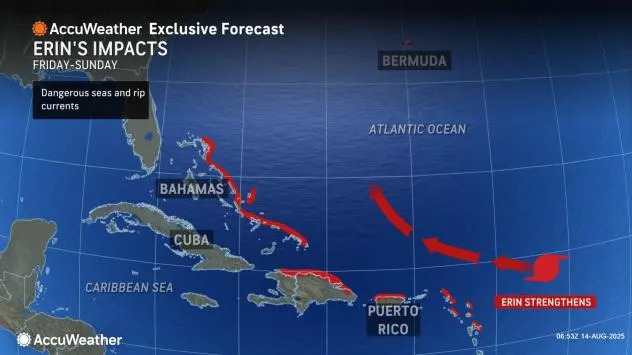
The greatest threats to these islands will come from dangerous surf and coastal flooding on the north-and northeast-facing beaches. If Erin tracks farther west before turning north, it could bring more serious and dangerous conditions to areas from Hispaniola to the Bahamas.
Beyond the Caribbean, Erin is forecast to maintain major hurricane strength as it turns more to the north-northwest and eventually north next week.
Massive swells generated by the storm will propagate outward, creating hazards for coastal areas in the United States and Bermuda and especially for vessels navigating the open waters in between. Deep-sea wave heights could exceed 50 feet.
Just as a prolonged westward track would increase the risk of direct impacts in the northern Caribbean, the same delay in the northward turn could bring Erin much closer to part of the eastern U.S.
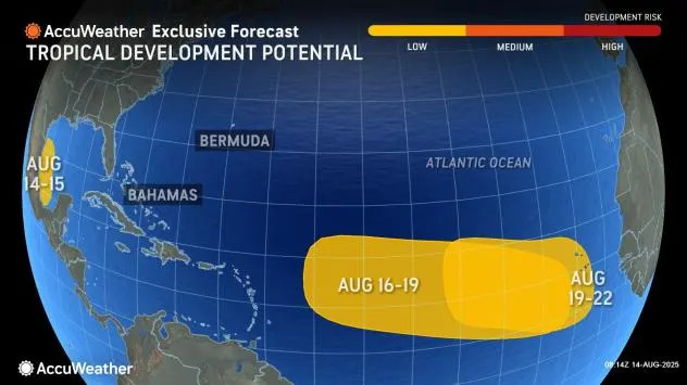
Farther out in the Atlantic, additional areas were being monitored for development and possible impacts in the weeks ahead.
Want next-level safety, ad-free? Unlock advanced, hyperlocal severe weather alerts when you subscribe to Premium+ on the AccuWeather app. AccuWeather Alerts™ are prompted by our expert meteorologists who monitor and analyze dangerous weather risks 24/7 to keep you and your family safer.


Comments