In a rush? Get an abbreviated, text view of what's happening with Hurricane Erin.
While Hurricane Erin's center is expected to stay east of Florida and the United States' east coast, it's still expected to bring some impacts, both directly and indirectly.
Some wind and rain are possible for North Carolina's Outer Banks, and evacuations and a state of emergency are in effect for some communities in the area.
➤ Weather alerts via text: Sign up to get updates about current storms and weather events by location
There is a risk for dangerous surf and life-threatening rip currents along the entire east coast, including most of Florida, said Michael Brennan, National Hurricane Center director.
The highest one-third of its waves could exceed 20 to 30 feet, and even 50 feet near the storm’s center.
“This is going to make for very dangerous marine conditions across all of the western Atlantic and increase the risk for dangerous and life-threatening surf and rip current conditions across almost the entire US East Coast,” Brennan said.
Here's what Florida can expect:
Jacksonville: 'Don't go in the surf; even knee deep is too deep'
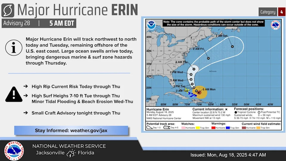
A high rip current risk is in effect for Northeast Florida beaches and southeast Georgia from Monday, Aug. 18, through Thursday, Aug. 21.
"Powerful ocean swells from Hurricane Erin arrive at area beaches this afternoon and evening," the National Weather Service Jacksonville said Monday, Aug. 18.
Surf heights could reach 7 to 10 feet Aug. 19 through Aug. 21, bringing minor tidal flooding and beach erosion with the highest surf expected Wednesday, Aug. 20.
"Rip currents can sweep even the best swimmers away from shore into deeper water," the National Weather Service Jacksonville posted on X.
An increasing ocean swell has already been detected on ocean buoys off the coast of Jacksonville, Florida, the National Weather Service said Monday.
The swells will grow in size through mid-week, creating a life-threatening situation for any swimmer venturing into the ocean, said Andrew Shashy, a meteorologist with he National Weather Service Jacksonville.
“Knee deep is too deep.”
"Don't go in the water. The currents and the surf will be too powerful, even for a great swimmer," Shashy said.
In Northeast Florida, ocean breakers of greater than seven feet are expected Tuesday through Thursday, according to the Weather Service, with the peak wave height around high tide on Wednesday. Minor coastal and tidal flooding is possible with "at least moderate beach erosion," said NWS meteorologist Angela Enyedi. Moderate beach erosion is possible during the early Wednesday evening high tide.
Here's a breakdown for the week:
Monday: Seas will build to the 3-5 foot range this afternoon both near shore and offshore. Breakers will gradually build to the 2-4 foot range this afternoon and evening at the northeast FL beaches
Tuesday: Seas will build to 6-8 feet offshore after midnight and to Caution levels of 4-6 feet near shore this evening, building further to 5-7 feet during the predawn hours on Tuesday. Deadly surf conditions will begin on Tuesday all along the coast, with breaker heights building to 6-8 feet by the afternoon hours at Northeast Florida beaches
Wednesday: Seas will peak in the 8-11 foot range near shore on Wednesday and Wednesday night, while seas offshore peak in the 11-14 foot range on Wednesday. A high surf advisory will likely be issued for the Northeast Florida beaches from Tuesday through at least Thursday night, with breakers peaking in the 9-11 foot range on Wednesday.
Thursday: Expect seas ranging from 6 to 9 feet, Shashy said, and to remain elevated through the weekend.
Florida east coast from Daytona Beach to Stuart: Expect seas up to 14 feet
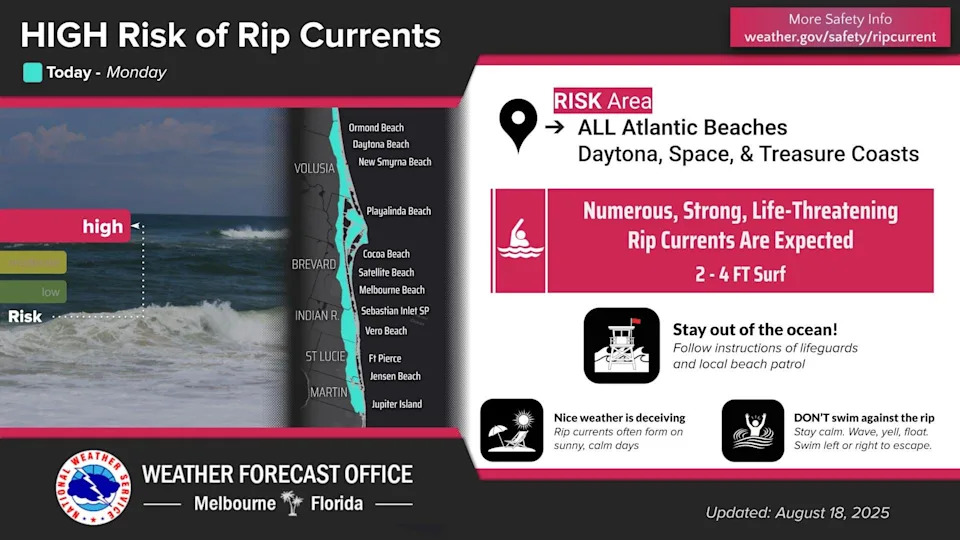
A high rip current risk is in effect from Monday, Aug. 18, through Thursday, Aug. 21.
Numerous, strong, life-threatening rip currents and increasing rough surf are expected along all central Florida Atlantic beaches.
The National Weather Service Melbourne predicted the following wave heights this week, and noted winds and waves could be higher in and near thunderstorms.
Tuesday: Seas 6 to 8 feet, occasionally to 10 feet.
Wednesday: Seas 9 to 11 feet, occasionally to 14 feet.
Thursday: Seas 5 to 7 feet, occasionally to 9 feet.
Friday: Seas 5 to 6 feet, occasionally to 8 feet.
South Florida from West Palm Beach to Miami
On Tuesday, Aug. 19, Erin is expected to make its closest pass to the Florida peninsula well off to the east, according to the National Weather Service Miami.
Wave heights remain at one foot or less for Atlantic waters on Monday and Gulf waters on Monday and Tuesday. Wave heights increase to 3 to 4 feet across northern Atlantic waters on Tuesday.
"Increasing swell from Erin is expected as early as Tuesday, but more likely mid to late week. This will result in an increasing rip current threat for the Atlantic beaches and possible high surf concerns for Palm Beach County," according to the National Weather Service.
Although South Florida will see elevated seas and swell from Erin, the Bahamas will shield the region to some extent, said hurricane specialist Michael Lowry in an Aug. 18 post on his Substack blog.
Coastal waters south of Palm Beach County will experience fewer problems than the more northern beaches as Erin passes, Lowry said.
What is a rip current?
Rip currents are powerful channels of water flowing quickly away from shore, which occur most often at low spots or breaks in the sandbar and in the vicinity of structures such as jetties and piers.
Rip currents form when incoming waves create an underwater sandbar. The waves push more water between the sandbar and the shore until it collapses and the water rushes back to the sea through a narrow gap, where it starts to spread out. But they can be difficult to see when you're in the water as the ocean over them can still be smooth.
Entering the surf is strongly discouraged. If caught in a rip current, relax and float. Don`t swim against the current. If able, swim in a direction following the shoreline. If unable to escape, face the shore and call or wave for help.
How dangerous are rip currents?
Rip currents are habitual hazards of Florida beaches. Tens of thousands are rescued from rip currents in the U.S, every year and they make up 81.9% of all surf beach rescues, according to a 2018 report from the Natural Hazards and Earth System Sciences on lifeguard data.
The United States Lifesaving Association has estimated that over 100 people drown every year in the U.S. due to rip currents.
Where is Hurricane Erin going?
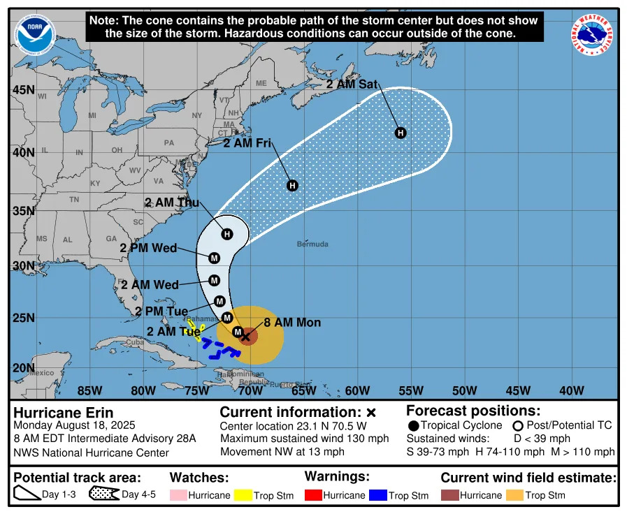
Special note on the NHC cone: The forecast track shows the most likely path of the center of the storm. It does not illustrate the full width of the storm or its impacts, and the center of the storm is likely to travel outside the cone up to 33% of the time.
Hurricane Erin spaghetti models
Special note about spaghetti models: Illustrations include an array of forecast tools and models, and not all are created equal. The hurricane center uses only the top four or five highest performing models to help make its forecasts.
➤ How often has Florida been impacted, threatened by August hurricanes? We took a look back
Hurricane Erin storm tracker, path
Weather watches and warnings issued in Florida
Florida weather radar for Aug. 18, 2025
Stay informed. Get weather alerts via text
What's next?
We will update our tropical weather coverage daily.
Download your local site's app to ensure you're always connected to the news. And look for our special subscription offers here.
Contributing: C.A. Bridges, USA Today Network-Florida
This article originally appeared on Treasure Coast Newspapers: Hurricane Erin wave heights, rip currents expected in Florida


Comments