Dangerous conditions continue across Florida Tuesday, July 29, with most of the state under either extreme heat warnings or heat advisories.
The notable exception continues to be South Florida, where temps are expected to reach the 90s but stay below the threshold for heat watches and warnings.
➤ Weather alerts via text: Sign up to get updates about current storms and weather events by location
The heat index in several areas is expected to reach as high as 115 on July 29.
➤ See when heat watches and warnings could be issued in your area
Here's what you should know about the extreme heat warnings and watches in effect and what they mean.
Tampa, Florida, ties record heat index, hitting 118 degrees
On Monday, July 28, Tampa's heat index hit 118, tying the record of 118 set on Aug. 6, 2000, according to Stephen Shiveley, meteorologist with the National Weather Service Tampa Bay.
Heat warnings, watches, advisories in effect across Florida
Quick look at conditions around Florida Tuesday, July 29
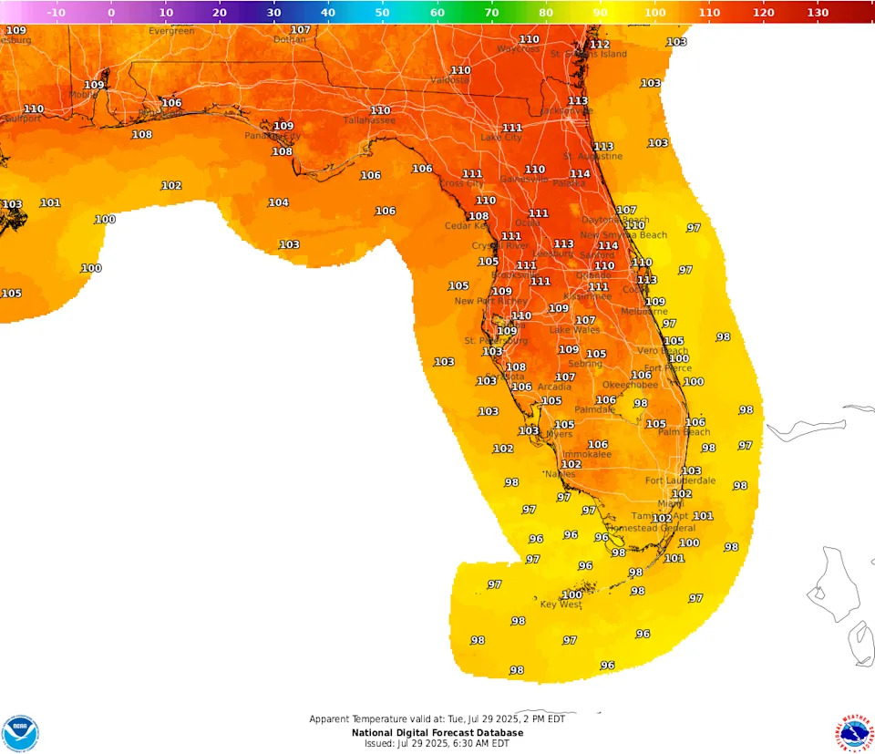
Pensacola, western Panhandle: Another hot and humid day is in store for the area. High temps will warm into the upper 90s, with heat indices topping out between 108-112 degrees.
Tallahassee, central Panhandle: Dangerous heat continues the next few days from noon to early evening. Highs from 96 to 100, with heat indices between 106 and 112.
Jacksonville, North, Northeast Florida: Dangerous heat continues today. Heat indices will soar to 108-115 degrees this afternoon. Extreme heat warnings and heat advisories are in effect from noon to 7 p.m.
Daytona Beach to Stuart, central and eastern Florida: An extreme heat warning and heat advisory are in effect from noon until 7 p.m. today for east Central Florida. The extreme heat warning covers areas from Greater Orlando northward. Dangerous heat is expected.
South Florida: Afternoon heat index values over 100 degrees will continue this week across South Florida. High temperatures in the 90s.
Southwest, western Florida: An excessive heat warning has been issued for the Nature Coast and Tampa Bay area counties, and a heat advisory has been issued southern portions of West Central Florida from noon to 7 p.m.
How long will Florida heat last? When will it get cooler?
"That's the question everyone wants the answer to," Stephen Shiveley, meteorologist with the National Weather Service Tampa Bay said in a telephone interview Tuesday morning.
The higher-than-average temperatures are "going to last for a good part of the work week," said Matt Volkmer, meteorologist with the National Weather Service Melbourne in a phone interview Tuesday morning.
"It's going to be pretty hot this week and we expect more heat advisories, especially for the interior."
There may be some relief in sight for the weekend or early next week. Note the word "some."
Models are showing temperatures could drop closer to average due to the cooling effects of storms and cloud cover, Volkmer said.
With temperatures Tuesday expected to be in the upper 90s to 100 — which is well above normal highs — in the Orlando area, by the weekend temperatures could be in the lower 90s, which is about normal for the area in early August.
Along Florida's west coast, Tuesday "should be last day of extreme heat, with temps in upper 90s and a heat index of 110 and above. Starting Wednesday, it will cool down slightly, more into the mid to low 90s instead of the upper 90s, with a heat index of Florida normal, about 105," Shiveley said.
By Sunday or Monday, "we may finally get closer to average, with a chance for rain, although the chances for rain on the west coast" are lower than along the east coast and Central Florida, Shiveley said.
Extreme heat warnings issued for 28 Florida counties
Heat warnings are in effect until 7 p.m. for the following counties:
What is an extreme heat warning?
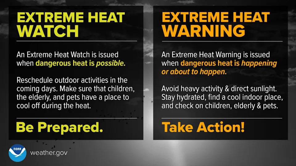
An extreme heat warning is issued when dangerous heat is happening or about to happen. Residents are advised to take action.
"An extreme heat warning is issued when extremely dangerous heat conditions are expected or occurring," the National Weather Service said.
When is an extreme heat warning issued in Florida?
There are slight differences around the state on when extreme heat warnings are issued:
Western Panhandle: This is issued if the heat index is expected to reach 113 degrees or higher over the next 12 to 24 hours or the air temperature is expected to hit 105 degrees.
Central Panhandle, North Florida: This is issued is the heat index is expected to reach 113 degrees or the air temperatures is forecast to reach 105 degrees within the next 6 to 24 hours.
Northeast Florida: This is issued if the heat index is expected to be 113 degrees within the next 12 to 24 hours.
East Central Florida: This is issued if a heat index of 113 degrees is expected in the next 24 hours.
In South Florida: This is issued if there is certainty the heat index will hit 113 degrees for two hours or longer.
Southwest, West Central Florida: This is issued if the heat index is expected to reach 113 degrees or the air temperature is forecast to reach 105 degrees within the next 24 hours.
What should you do when there is an extreme heat warning?
"Avoid outdoor activities, especially during the heat of the day. If you must be outside, be sure to drink plenty of water and take frequent breaks in the shade," the National Weather Service said.
"Stay indoors in an air-conditioned space as much as possible, including overnight. Check on family and neighbors," especially children, the elderly and pets.
Heat advisory issued for 30 Florida counties
A heat advisory is in effect for the following counties:
What is a heat advisory?
A heat advisory is issued for dangerous heat conditions that are not expected to reach warning criteria, according to the National Weather Service.
When a heat advisory is issued also depends on where you are in Florida.
For most of the state, a heat advisory is issued if the heat index is expected to be between 108 to 112 degrees.
Here is the breakdown by each NWS region. A heat advisory is issued when the heat index is expected to be:
Western Panhandle: 108-112 degrees
Central Panhandle, North Florida: 108 to 112 within the next 6 to 24 hours or air temperature is forecast to reach 103 degrees
Northeast Florida: 108-112 degrees
East Central Florida: 108 to 112 degrees
In South Florida: 108 degrees in South Florida or 105 degrees for Miami/Dade and Broward counties
Southwest, West Central Florida: 108-112 or the air temp is greater or equal to 103 degrees
The National Weather Service Miami said Miami/Dade County wanted a lower threshold for a heat advisory for its population.
What should you do when there is a heat advisory?
"Residents are advised to consider postponing or rescheduling outdoor activities, especially during the heat of the day," the National Weather Service said.
"If you must be outside, be sure to drink plenty of water and take frequent breaks in the shade. Stay in a cool place, especially during the heat of the day and evening."
Tampa, Florida, sets record high temperature of 100 degrees
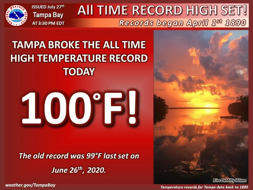
On July 27, Tampa set an all-time record high temperature of 100 degrees, according to the National Weather Service Tampa Bay.
The prior record was 99, set on June 26, 2020.
The National Weather Service Tampa Bay explained why it's unusual for the area to get temperatures as high as 100.
"Why has Tampa never hit 100? The airport sits on the edge of Tampa Bay. The sea breeze is usually able to move in and cool things down before temps can quite get that hot. A combo of multiple hot, dry days and a strong NE wind kept that from happening today (July 27), breaking the record," the agency posted on X.
Records date back to April 1, 1890.
Heat index and temperature map for US, Florida
National Hurricane Center tracking 4 tropical waves
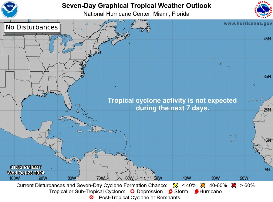
All is quiet in the tropics, with no development expected over the next seven days. The National Hurricane Center is monitoring four tropical waves, including three in the Caribbean.
Stay informed. Get weather alerts via text
What's next?
We will provide weather coverage as conditions warrant.
Download your local site's app to ensure you're always connected to the news. And look for our special subscription offers here.
This article originally appeared on Florida Times-Union: Extreme heat warnings issued in Florida as heat index soars to 115


Comments