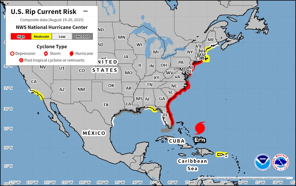
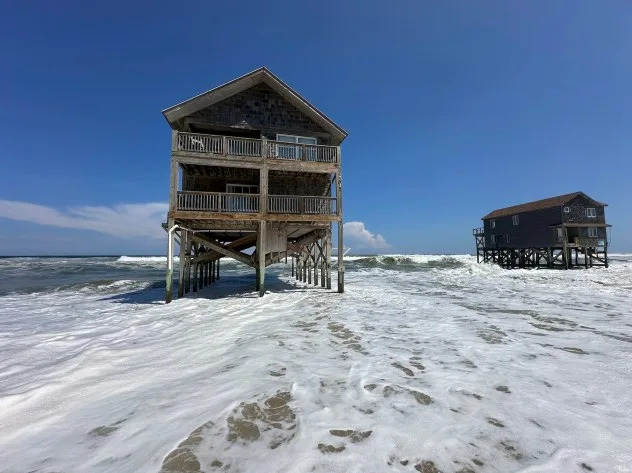
Hurricane Erin unleashed powerful waves and rip currents along the East Coast, threatening beachfront homes and flooding roads as authorities urged people to stay out of the water.
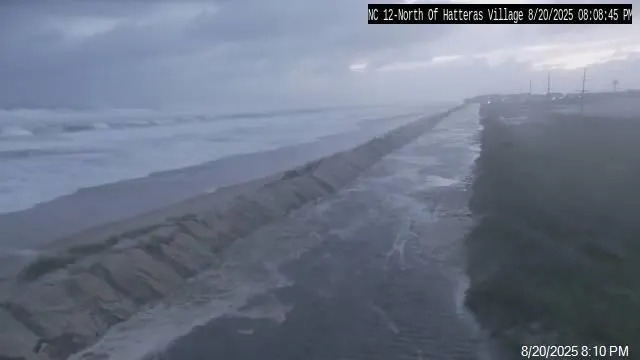
The National Hurricane Center warned that roads on the low-lying barrier islands could become impassable, with waves of 15 to 20 feet crashing ashore. By the evening of Wednesday, Aug. 20, the North Carolina Department of Transportation closed a portion of N.C. 12, a crucial artery in the Outer Banks, due to flooding.
Major flooding was forecast at more than half a dozen tidally influenced locations along the mid-Atlantic coast, including Duck, North Carolina; the entrance to the Chesapeake Bay; and Lewes, Delaware. The National Weather Service said flooding at some of these sites posed a "significant threat" to property and life, prompting evacuations.
As of early Thursday, Aug. 21, Hurricane Erin is beginning to move away from the North Carolina coast, according to the latest advisory from the National Hurricane Center.
➤ Weather alerts via text: Sign up to get updates about current storms and weather events by location
Has Hurricane Erin passed South Carolina?
Hurricane Erin has not fully moved past South Carolina. However, the storm is no longer tracking north-northwest toward the U.S. and has shifted slightly, now curving to the north-northeast. It is expected to dissipate over the open Atlantic by early Saturday, Aug. 23.
High surf, flooding, rip currents and coastal erosion are expected to persist Thursday, Aug. 21.
At 5 a.m., Erin was located 205 miles east-southeast of Cape Hatteras, North Carolina. Maximum sustained winds were 105 mph.
When will beaches reopen?
No-swim advisories in South Carolina are in effect through Friday, Aug. 22. However, hazardous conditions may persist through the weekend, so full beach access might not resume until later in the weekend, depending on recovery efforts, safety assessments and the extent of any damage.
Where is Hurricane Erin going? See projected path
Special note on the NHC cone: The forecast track shows the most likely path of the center of the storm. It does not illustrate the full width of the storm or its impacts, and the center of the storm is likely to travel outside the cone up to 33% of the time.
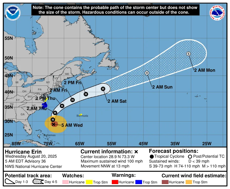
Here's the latest Aug. 21 update on Hurricane Erin.
Location: 205 miles south-southeast of Cape Hatteras North Carolina
Maximum sustained winds: 105 mph
Movement: north-northeast at 17 mph
Pressure: 945 mb
Life-threatening impacts persist in South Carolina
Hurricane Erin is not expected to make landfall on the U.S. but will continue to bring significant risks along East Coast beaches from Florida to Maine through early Friday, Aug. 22.
The storm’s rapid intensification has prompted increased emergency measures in North Carolina, and the Outer Banks — a popular summer vacation spot — are now under a state of emergency. Officials mandated evacuations for Hatteras Island, Ockracoke and Dare County, residents to leave by 8 a.m. Tuesday, Aug. 19, as forecasters warned of life-threatening rip currents, large swells, coastal flooding and road washouts.
"We cannot put this more bluntly: We now EXPECT there will be times over the next week that NC12 becomes impassable due to significant ocean over wash," North Carolina Department of Transportation said in a statement Monday, Aug. 18. "In a worst-case scenario, the highway could be closed for several days. Please heed the evacuation orders and keep you and your family safe."
In a separate advisory, National Hurricane Center Director Michael Brennan earlier this week added that "breaking waves of 15 to 20 feet plus coastal flooding and storm surge could over wash dunes and flood homes and flood roads and make some communities impassable."
“These are going to be situations where you’re not going to want to be in the ocean, and you're going to want to heed any precautions given by your local officials,” he said. “Even though the weather can be nice at the coast, it can still have dangerous surf and rip current c
Hurricane Erin projected path
Hurricane Erin spaghetti models
Special note about spaghetti models: Illustrations include an array of forecast tools and models, and not all are created equal. The hurricane center uses only the top four or five highest performing models to help make its forecasts.
When is the Atlantic hurricane season?
The Atlantic hurricane season runs from June 1 through Nov. 30.
Ninety-seven percent of tropical cyclone activity occurs during this time period, NOAA said. The season peaks in August and September.
The Atlantic basin includes the northern Atlantic Ocean, Caribbean Sea and Gulf of America, as the Gulf of Mexico is now known in the U.S. per an order from President Trump. NOAA and the National Hurricane Center are now using Gulf of America on its maps and in its advisories.
South Carolina weather radar
Stay informed. Get weather alerts via text
Brandi D. Addison covers weather across the United States as the Weather Connect Reporter for the USA TODAY Network. She can be reached at [email protected].
This article originally appeared on Greenville News: Hurricane Erin moving off East Coast. See spaghetti models, path


Comments