Hurricane Erin is moving north, and while the storm is not expected to make landfall, the East Coast is experiencing heavy winds, flooding and dangerous marine conditions as the storm travels up the Atlantic Ocean – including in New Hampshire and Maine.
For New Hampshire specifically, the National Weather Service (NWS) of Gray, Maine predicts the coast will experience some dangerous waves and rip currents, advising people to stay out of the water from Thursday, Aug. 21 through Saturday, Aug. 23.
In Maine, York County has issued a rip current and high surf alert through Sunday, Aug. 24.
"High risk of rip currents at the coast today and over the next few days," York County Emergency Management Agency said on X. "Dangerous swimming & surfing conditions are expected. Follow instructions from lifeguards & local officials & stay out of the water especially if you are an inexperienced swimmer."

Patrick Murphy, chief of Hampton Beach lifeguards in New Hampshire, is urging caution.
"We’ll have to see what Erin brings, and we’ll adjust accordingly,” he said. “Our No. 1 goal is to keep every patron that steps foot on any of our New Hampshire State Park Seacoast beaches, from Hampton Beach to Wallis Sands, safe. When people come to the beach, we want them to come to beaches with lifeguards on duty. Check in with a lifeguard, swim near a lifeguard.”
Here's what to know:
Will Hurricane Erin impact New Hampshire?
The NWS predicts that Hurricane Erin will pass southeast of New England on Friday, Aug. 22, bringing a large swell to into the Gulf of Maine. With its large waves, this swell will create dangerous rip currents, which will create dangerous swimming and surfing conditions and can even cause some beach erosion.
While the main threat in New Hampshire is these rip currents, the NWS warns that some minor coastal flooding is also possible on the Seacoast surrounding the Friday night high tide.
As a result of the storm, the NWS has issued a Rip Current Statement, a High Surf Advisory and a Small Craft Advisory for the coast of New Hampshire, warning that swimmers and smaller vessels should stay out of the water from now through end of day Saturday, Aug. 23.
What are rip currents?
Rip currents are powerful channels of fast-moving water, and they have killed about 50 people in the U.S. so far this year, according to a release last week from AccuWeather.
If you are caught in a rip current, officials advise you to swim parallel to the shore until you are out of the channel, AccuWeather noted in the release.
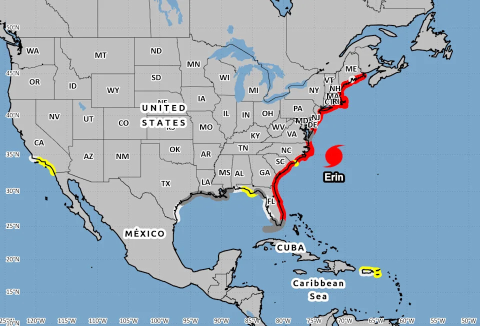
Hurricane Erin path tracker
This forecast track shows the most likely path of the center of the storm. It does not illustrate the full width of the storm or its impacts, and the center of the storm is likely to travel outside the cone up to 33% of the time.
2025 hurricane forecast
The AccuWeather 2025 Atlantic hurricane season forecast is predicting 13-18 named storms, including 7-10 hurricanes, adding "Three to six direct U.S. impacts are forecast, the same range as last year’s catastrophic season with six landfalls."
The report noted that the climatological peak of hurricane season begins Sept. 10.
USA TODAY Network reporters Dinah Voyles Pulver, John Bacon, Jeanine Santucci, Jorge L. Ortiz, Brandon Ng and Seth Jacobson contributed to this article.
This article originally appeared on Portsmouth Herald: Hurricane Erin Track: See maps, impacts expected to NH, Maine


Comments