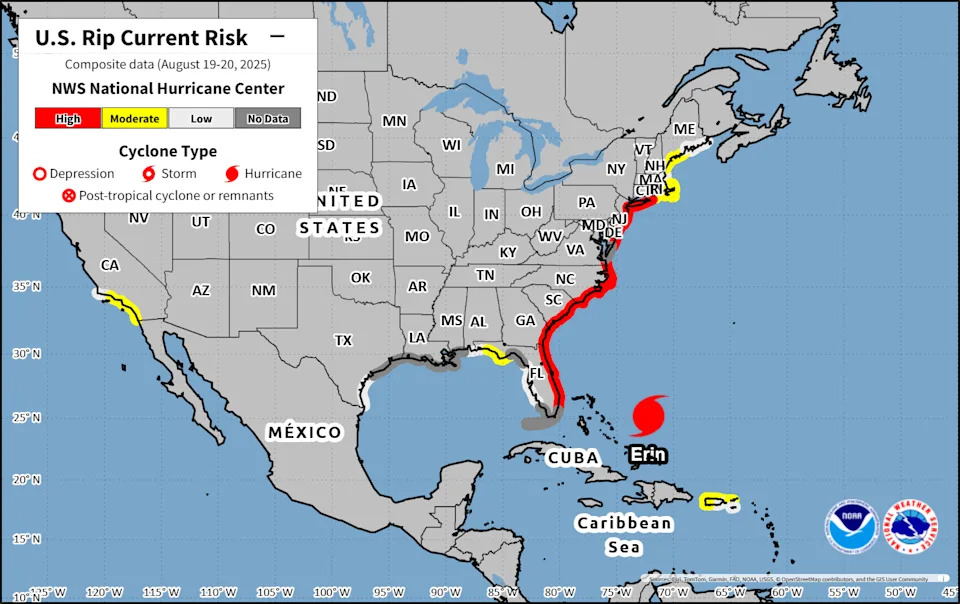
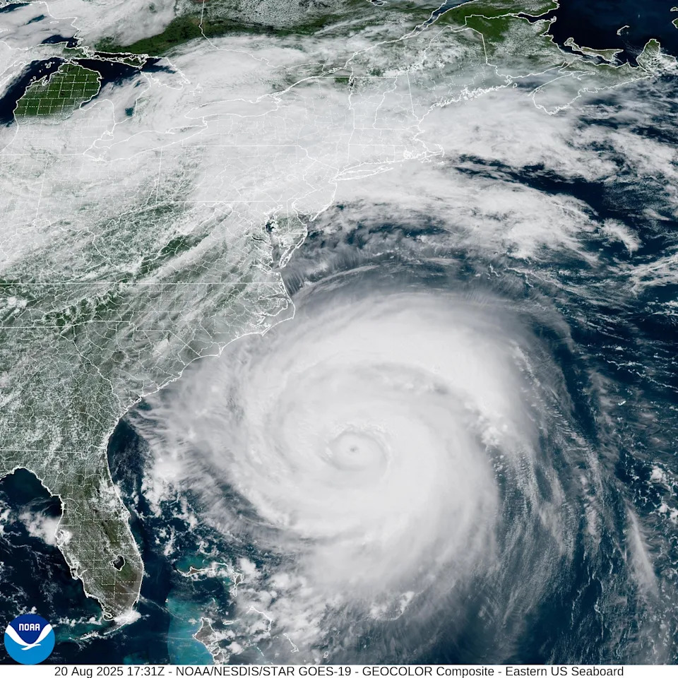
Hurricane Erin unleashed powerful waves and rip currents along the East Coast, threatening beachfront homes and flooding roads as authorities urged people to stay out of the water.
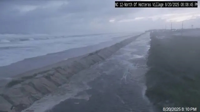
The National Hurricane Center warned that roads on the low-lying barrier islands could become impassable, with waves of 15 to 20 feet crashing ashore. By the evening of Wednesday, Aug. 20, the North Carolina Department of Transportation closed a portion of N.C. 12, a crucial artery in the Outer Banks, due to flooding.
Major flooding was forecast at more than half a dozen tidally influenced locations along the mid-Atlantic coast, including Duck, North Carolina; the entrance to the Chesapeake Bay; and Lewes, Delaware. The National Weather Service said flooding at some of these sites posed a "significant threat" to property and life, prompting evacuations.
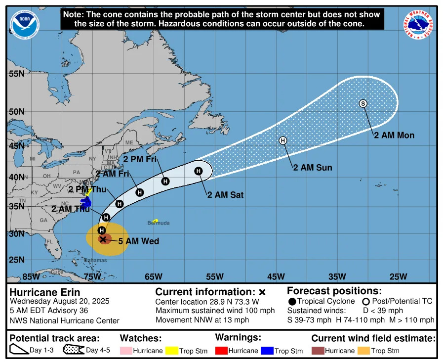
As of early Thursday, Aug. 21, Hurricane Erin is beginning to move away from the North Carolina coast, according to the latest advisory from the National Hurricane Center.
➤ Weather alerts via text: Sign up to get updates about current storms and weather events by location
Has Hurricane Erin passed North Carolina?
Hurricane Erin has not fully moved past North Carolina. However, the storm is no longer tracking north-northwest toward the U.S. and has shifted slightly, now curving to the north-northeast. It is expected to dissipate over the open Atlantic by early Saturday, Aug. 23.
High surf, flooding, rip currents and coastal erosion are expected to persist Thursday, Aug. 21.
At 5 a.m., Erin was located 205 miles east-southeast of Cape Hatteras, North Carolina. Maximum sustained winds were 105 mph.
Where is Hurricane Erin going? See projected path
Special note on the NHC cone: The forecast track shows the most likely path of the center of the storm. It does not illustrate the full width of the storm or its impacts, and the center of the storm is likely to travel outside the cone up to 33% of the time.
Here's the latest Aug. 21 update on Hurricane Erin.
Location: 205 miles south-southeast of Cape Hatteras North Carolina
Maximum sustained winds: 105 mph
Movement: north-northeast at 17 mph
Pressure: 945 mb
Life-threatening impacts persist in North Carolina
Hurricane Erin is not expected to make landfall on the U.S. but will continue to bring significant risk to North Carolina through early Friday, Aug. 22.
The storm’s rapid intensification prompted increased emergency measures in North Carolina, and the Outer Banks — a popular summer vacation spot — are under a state of emergency for several days. Officials mandated evacuations for Hatteras Island, Ockracoke and Dare County, residents to leave by 8 a.m. Tuesday, Aug. 19, as forecasters warned of life-threatening rip currents, large swells, coastal flooding and road washouts.
"We cannot put this more bluntly: We now EXPECT there will be times over the next week that NC12 becomes impassable due to significant ocean over wash," North Carolina Department of Transportation said in a statement Monday, Aug. 18. "In a worst-case scenario, the highway could be closed for several days. Please heed the evacuation orders and keep you and your family safe."
In a separate advisory, National Hurricane Center Director Michael Brennan earlier this week added that "breaking waves of 15 to 20 feet plus coastal flooding and storm surge could over wash dunes and flood homes and flood roads and make some communities impassable."
“These are going to be situations where you’re not going to want to be in the ocean, and you're going to want to heed any precautions given by your local officials,” he said. “Even though the weather can be nice at the coast, it can still have dangerous surf and rip current conditions from a hurricane that's well offshore like we're going to Erin.”
North Carolina watches and warnings
Tropical storm watch
Location: Coastal waters from Oregon Inlet to Surf City, North Carolina, including Cape Hatteras, Ocracoke Inlet, Cape Lookout and the Monitor National Marine Sanctuary
When: Wednesday evening through Thursday afternoon, Aug. 20-21.
High surf advisories
Coastal Pender and Coastal New Hanover counties, North Carolina — 5 a.m. Tuesday, Aug. 19, to 11 p.m. Thursday, Aug. 21
Coastal Brunswick County, North Carolina; Coastal Horry and Coastal Georgetown counties, South Carolina — 5 a.m. Tuesday, Aug. 19, to 11 p.m. Thursday, Aug. 21
West Carteret and Coastal Onslow counties, North Carolina — noon Tuesday, Aug. 19, to 8 p.m. Thursday, Aug. 21
Coastal flood watch
Location: West Carteret and Coastal Onslow counties, North Carolina
When: Tuesday afternoon through Thursday evening, Aug. 19-21.
Hurricane Erin: North Carolina Outer Banks evacuation routes
Dare County has two primary evacuation routes: U.S. 64 West and U.S. 158 North.
Emergency management officials are urging residents and visitors — particularly those evacuating Hatteras Island, Nags Head, and Roanoke Island — to use U.S. 64 West whenever possible.
See more about evacuation routes on the Dare County website.
Atlantic storm tracker
Hurricane Erin spaghetti models
Special note about spaghetti models: Illustrations include an array of forecast tools and models, and not all are created equal. The hurricane center uses only the top four or five highest performing models to help make its forecasts.
How does the 2025 Atlantic hurricane season compared to last year in North Carolina?
While the 2025 season may seem slow compared with 2024 — when Hurricane Beryl became the earliest Category 5 storm on record before its final landfall in Matagorda, Texas — Erin is actually right on schedule in terms of hurricane development.
Historically, the first hurricane forms around Aug. 11, the first major hurricane around Sept. 1 and the fifth named storm around Aug. 22, according to AccuWeather.
Forecasters say the season is entering its most active stretch. In their latest forecast, Colorado State University experts stuck to their early-summer outlook of a slightly above-average season: 16 named storms, including eight hurricanes, three of them major. A "normal" year sees 14 named storms, of which seven become hurricanes.
For North Carolina, the season has been quiet so far, following a similar pattern to 2024.
Around this time last year, Tropical Storm Debby brought heavy rain, flash flooding, tropical storm–force wind gusts, minor coastal flooding and three weak tornadoes to southeastern North Carolina after making landfall in Florida's Big Bend region on Aug. 5, 2024, and then a second landfall in South Carolina's Bulls Bay between Charleston and Georgetown early on Aug. 8, 2024.
By late September, the state tracked Tropical Storm Helene, which caused flash floods, landslides and hundreds of fatalities fatalities after moving through the Appalachians.
So far, no storms have directly affected the state, but Colorado State researchers say North Carolina has one of the highest odds of seeing impacts from a hurricane or named storm this season — second only to Florida.
When is the Atlantic hurricane season?
The Atlantic hurricane season runs from June 1 through Nov. 30.
Ninety-seven percent of tropical cyclone activity occurs during this time period, NOAA said. The season peaks in August and September.
The Atlantic basin includes the northern Atlantic Ocean, Caribbean Sea and Gulf of America, as the Gulf of Mexico is now known in the U.S. per an order from President Trump. NOAA and the National Hurricane Center are now using Gulf of America on its maps and in its advisories.
North Carolina weather radar
North Carolina weather watches and warnings
Stay informed. Get weather alerts via text
Brandi D. Addison covers weather across the United States as the Weather Connect Reporter for the USA TODAY Network. She can be reached at [email protected].
This article originally appeared on Asheville Citizen Times: Where is Hurricane Erin headed next? Projected path, spaghetti models


Comments