The Atlantic is seeing a surge in tropical activity as the massive Hurricane Erin races up the western Atlantic, Invest 99L shows signs of gradual development and the National Hurricane Center keeps tabs on two more disturbances.
Hurricane Erin made its closest brush with the U.S. East Coast early Thursday morning as a Category 2 hurricane, and is expected to pick up steam as it turns east-northeast and heads across the North Atlantic.
Meanwhile, Invest 99L and two other tropical disturbances are dancing across the Atlantic with varying chances of organizing into tropical depressions through the weekend.
Live updates: Hurricane Erin reaches closest approach to NC; dangers remain to East Coast: Updates
The closest tropical wave is near the Leeward Islands and is likely to form a depression over the weekend. Its current path has it tracking parallel to the East Coast. Similar to Erin's, it's not expected to make landfall.
Invest 99L is still several hundred miles west of the Cabo Verde Islands, which are located off Africa's western coast. Short-term conditions are favorable for a tropical depression to spawn from the system. In the long term, conditions are unfavorable for development, so the NHC expects any organization to be short-lived.
A small area of low pressure recently popped up about 1,200 miles southwest of the Azores, a group of volcanic islands in the Atlantic located about 900 miles west of Portugal. The system could see some marginal development over the next several days, but its eastward movement means it's of little concern for the U.S.
Hurricane Erin brings large swells to North Carolina shores
Erin battered the Outer Banks in North Carolina as a Category 2 hurricane as it moved past its closest approach to the U.S. East Coast on Thursday morning.
The storm brought 15- to 20-foot waves to low-lying barrier islands within the region despite its center being a couple of hundred miles away from the coastline. The North Carolina Department of Transportation closed a portion of Highway 12, a crucial artery in the Outer Banks, due to flooding.
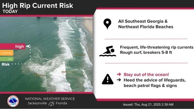
The East Coast and Bermuda will continue to see life-threatening surf and rip currents caused by Erin for the next several days, with surge flooding and tropical storm conditions persisting through Thursday.
Faster upper-level winds will hurry Hurricane Erin along, twisting its path east-northeast on Friday. From there, it will move across the North Atlantic at speeds reaching near 40 mph.
Quick facts about Hurricane Erin: 10 a.m. update
The center of Hurricane Erin was located near latitude 35.4 North, longitude 70.9 West. Erin is moving toward the north-northeast near 18 mph (30 km/h).
A faster northeastward to east-northeastward motion is expected during the next couple of days. On the forecast track, the center of Erin will move over the western Atlantic between the U.S. east coast and Bermuda through early Friday, and then pass south of Atlantic Canada Friday and Saturday.
Maximum sustained winds are near 100 mph (155 km/h) with higher gusts. Gradual weakening is forecast during the next couple of days. Erin is expected to become post-tropical on Saturday.
Erin is a very large hurricane. Hurricane-force winds extend outward up to 105 miles (165 km) from the center and tropical-storm-force winds extend outward up to 320 miles (520 km).
A WeatherFlow station at Jennette's Pier in Nags Head, North Carolina, recently measured a sustained wind of 44 mph (70 km/h) and a gust to 52 mph (83 km/h).
Location: 260 miles east of Cape Hatteras North Carolina, 410 miles west-northwest of Bermuda.
Maximum wind speeds: 100 mph
Movement: North-northeast (325 degrees) at 18 mph
Minimum central pressure: 952 mb
Are there any tropical storms or hurricanes headed to Florida's Gulf Coast?
The National Hurricane Center's latest advisory is all good news for Florida Gulf Coast residents: There's nothing major to report.
Trade winds are returning to the central and eastern Caribbean as Erin moves away, which will help bring a bit of stability to weather patterns in the area. Persistent trade winds can lead to choppier waters but also help suppress storms.
On the other hand, easterly winds are also responsible for steering budding storms from the coast of Africa westward to the Caribbean and North America.
Conditions in the Gulf are extremely tame. Winds are light and wave action is pretty low, around one to two feet.
Is Ferdinand right behind Hurricane Erin?
As Erin makes its way toward North Atlantic seas and we continue wading through the peak of the Atlantic hurricane season, it's crucial to turn our attention toward what else is happening.
Near the Leeward Islands in the Tropical Atlantic: An area of showers and thunderstorms associated with a tropical wave located a few hundred miles east of the Leeward Islands has changed little over the past several hours. Environmental conditions appear conducive for further development of this system, and a tropical depression is likely to form this weekend while it moves near or to the north of the northern Leeward Islands.
Formation chance through 48 hours: 40%
Formation chance through 7 days: 70%
Showers and thunderstorms associated with a tropical wave located several hundred miles west-southwest of the Cabo Verde Islands show some signs of organization. Environmental conditions appear marginally favorable for additional development over the next day or so while the system moves west-southwestward at around 15 mph, and a short-lived tropical depression could form. In a couple of days, environmental conditions are expected to become unfavorable for further development.
Formation chance through 48 hours: 40%
Formation chance through 7 days: 40%
A small area of low pressure located about 1,200 miles southwest of the Azores is producing limited showers and thunderstorms. Upper-level winds are only marginally conducive for development while the system moves slowly eastward over the next couple of days
Formation chance through 48 hours: 30%
Formation chance through 7 days: 30%
Ferdinand will be the next named storm in the Atlantic.
Hurricane Erin’s current impacts
Erin will continue to produce life-threatening surf and rip currents along the beaches of the Bahamas, much of the east coast of the U.S., Bermuda, and Atlantic Canada during the next several days. Beachgoers in those areas should follow advice from lifeguards, local authorities and beach warning flags.
Storm surge flooding and tropical storm conditions will continue on the North Carolina Outer Banks Thursday. The storm surge will be accompanied by large waves, leading to significant beach erosion and overwash, making some roads impassible.
Tropical storm conditions are expected Thursday along the Virginia coast. Wind gusts to tropical storm force are likely along portions of the remainder of the U.S. Mid-Atlantic and southern New England coasts through early Friday.
Tropical storm conditions are possible on Bermuda this afternoon through early Friday. Gusts to gale force are possible along the coast of Nova Scotia on Friday and the Avalon Peninsula of Newfoundland on Saturday.
Hurricane Erin spaghetti models
Special note about spaghetti models: Illustrations include an array of forecast tools and models, and not all are created equal. The hurricane center uses only the top four or five highest performing models to help make its forecasts.
Hurricane Erin watches and warnings
A Storm Surge Warning is in effect for:
Cape Lookout to Duck, North Carolina
A Tropical Storm Warning is in effect for:
Beaufort Inlet, North Carolina to Chincoteague, Virginia, including Pamlico and Albemarle sounds.
A Tropical Storm Watch is in effect for:
Bermuda
A Tropical Storm Warning means that tropical storm conditions are expected somewhere within the warning area, in this case within the next 24 hours.
A Tropical Storm Watch means that tropical storm conditions are possible within the watch area, generally within 48 hours.
A Storm Surge Warning means there is a danger of life-threatening inundation, from rising water moving inland from the coastline, during the next 36 hours in the indicated locations.
This article originally appeared on Pensacola News Journal: Atlantic hurricane season activity surges with Erin, 3 disturbances


Comments