Hurricane Erin is weakening as it moves away from the United States, according to the latest advisory from the National Hurricane Center.
The Category 2 storm never made landfall along the U.S. coast Thursday, Aug. 21, but large surf and rip currents posed threats along the coast from Florida to Canada.
➤ Weather alerts via text: Sign up to get updates about current storms and weather events by location
Expect dangerous rip currents to continue along much of Florida's coast Friday, Aug. 22. The National Weather Service Melbourne warned "numerous, strong, life-threatening rip currents are expected, along with 3-4 foot surf and seas 4-6 feet high.
"Stay out of the ocean!"
Conditions along the east coast of Florida are likely to improve to typical by the weekend, according to AccuWeather.
Erin is expected to become post-tropical by tonight as it speeds into the North Atlantic.
Hurricane Erin projected path. See current location
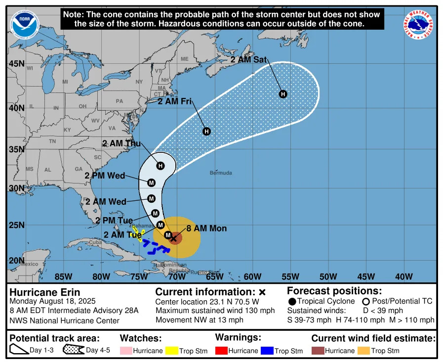
Special note on the NHC cone: The forecast track shows the most likely path of the center of the storm. It does not illustrate the full width of the storm or its impacts, and the center of the storm is likely to travel outside the cone up to 33% of the time.
Location: 435 miles north of Bermuda; 425 miles south-southwest of Halifax, Nova Scotia
Maximum sustained winds: 90 mph
Movement: northeast at 22 mph
Pressure: 956 mb
Next advisory: 8 a.m. ET
Impacts felt in US from Hurricane Erin
The maximum observed wind gust as of Friday morning in the United States was 53 mph in Cape Hatteras, North Carolina, according to AccuWeather.
Hurricane Erin produced a storm surge of around 3 feet along portions of North Carolina's Outer Banks and southeastern Virginia, with waves of 10 to 20 feet in the surf zone on top of the surge.
➤ Hurricane Erin unleashes powerful waves and rip currents; storm pulls away from coast
Some roads, including Highway 12 in North Carolina's Outer Banks, were under water as waves of 15 to 20 feet came ashore.
In New Jersey, coastal flooding closed U.S. 40 in both directions in Pleasantville, near Atlantic City.
In Delaware, the water washed over the tops of dunes and caused some beach erosion on the north side of Indian River Inlet in Sussex, according to the National Weather Service.
Spirit Airlines flies through Cat 4 Hurricane Erin

A Spirit Airlines flight from Philadelphia to San Juan appeared to have flown directly through the path of Hurricane Erin Aug. 18.
The airline said the course was completely safe. Spirit told USA TODAY the flight operated normally and there were no injuries reported when it landed.
➤ Spirit flight sparks storm fears after flying near Hurricane Erin
"The aircraft was at FL 370 (37,000 feet) and only light turbulence was reported in that area," Michael McCormick, coordinator of the Air Traffic Management Program at Embry-Riddle Aeronautical University, told USA TODAY in a written statement.
"At that altitude, the aircraft would be above the significant weather with the worst activity to the north of the flight path."
At the time, Hurricane Erin was a Category 4 storm.
Spaghetti models for Hurricane Erin. Where is storm going now?
Special note about spaghetti models: Illustrations include an array of forecast tools and models, and not all are created equal. The hurricane center uses only the top four or five highest performing models to help make its forecasts.
What impact is Hurricane Erin having on Florida Aug. 22?

Expect dangerous rip currents to continue along much of Florida's coast Friday, Aug. 22.
The National Weather Service Melbourne warned "numerous, strong, life-threatening rip currents are expected, along with 3-4 foot surf and seas 4-6 feet high.
"Stay out of the ocean!"
How strong is Hurricane Erin and where is it going now?
At 5 a.m., the center of Hurricane Erin was located near latitude 38.6 North, longitude 65.3 West.
Erin is moving toward the northeast near 22 mph. A turn toward the east-northeast with an increase in forward speed is expected later today, followed by a turn back to the northeast on Sunday.
On the forecast track, the center of Erin will pass south of Atlantic Canada today and tonight, and then race across the north Atlantic waters.
Maximum sustained winds are near 90 mph, with higher gusts. Erin is likely to become post-tropical by tonight but remain a powerful hurricane-force low pressure system through the weekend.
Erin remains a very large hurricane. Hurricane-force winds extend outward up to 125 miles from the center and tropical-storm-force winds extend outward up to 370 miles.
Watches and warnings issued for Hurricane Erin
There are no coastal watches or warnings now in effect for Hurricane Erin.
Hazards affecting land from Hurricane Erin
Wind: Wind gusts to tropical storm force are possible in extreme southeastern Massachusetts during the next couple of hours. Gusts to gale force are possible along portions of the coast of Nova Scotia today and the Avalon Peninsula of Newfoundland on Saturday.
Surf: Swells generated by Erin will affect the Bahamas, Bermuda, the east coast of the United States, and Atlantic Canada during the next several days. These rough ocean conditions are expected to cause life-threatening surf and rip currents.
Storm surge: Coastal flooding is expected at times of high tide along portions of the U.S. Mid-Atlantic and New England coasts through tonight, making some roads impassable.
Key messages from the National Hurricane Center: What you need to know about Hurricane Erin
Erin will continue to produce life-threatening surf and rip currents along the beaches of the Bahamas, much of the east coast of the U.S., Bermuda, and Atlantic Canada during the next several days. Beachgoers in those areas should follow advice from lifeguards, local authorities, and beach warning flags.
Coastal flooding is expected at times of high tide along portions of the U.S. Mid-Atlantic and New England coasts through tonight, making some roads impassable. Large waves along the coast could also cause significant beach erosion and overwash.
Gusts to gale force are possible along the coast of Nova Scotia today and the Avalon Peninsula of Newfoundland on Saturday.
Current forecast: How fast will Hurricane Erin weaken?
At 5 a.m.: 90 mph
12 hours: 90 mph; post-tropical, extratropical
24 hours: 85 mph; post-tropical, extratropical
36 hours: 80 mph; post-tropical, extratropical
48 hours: 80 mph; post-tropical, extratropical
60 hours: 85 mph; post-tropical, extratropical
72 hours: 75 mph; post-tropical, extratropical
96 hours: 50 mph; post-tropical, extratropical
120 hours: 45 mph; post-tropical, extratropical
Hurricane categories: Saffir-Simpson Hurricane Wind Scale
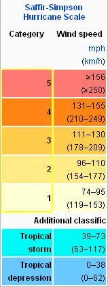
Category 1 hurricane: 74-95 mph
Category 2 hurricane: 96-110 mph
Category 3 hurricane: 111-129 mph
Category 4 hurricane: 130-156 mph
Category 5 hurricane: 157 mph or higher
Stay informed. Get weather alerts via text
What's next?
We will update our tropical weather coverage daily.
Download your local site's app to ensure you're always connected to the news. And look for our special subscription offers here.
Contributor: USA Today
This article originally appeared on Treasure Coast Newspapers: Hurricane Erin: Florida, US impacts. Updates, tracker, path


Comments