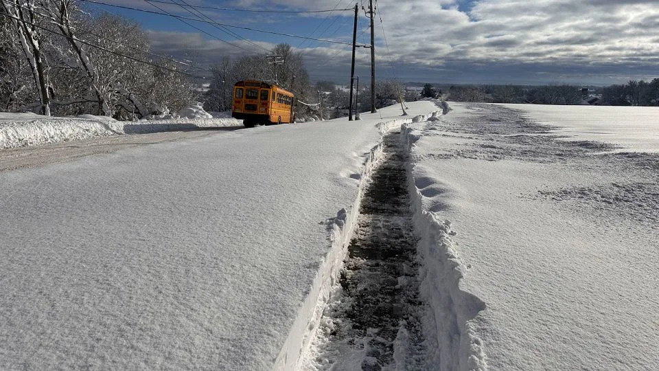
As a taste of fall gives much of the United States a break from a hot, humid summer, some forecasters are already skipping ahead to winter, and a possible homecoming for an important atmospheric player: La Niña.
La Niña has about coin-flip odds of emerging this fall, with a 53% chance from September through November, according to the latest National Oceanic and Atmospheric Administration forecasts. It has a slightly better chance – 58% – of emerging by the end of the year. The odds are good enough to have triggered a La Niña watch from NOAA.
Once it arrives, it’s likely to stick around for much of the winter and make its mark on the country’s temperature and precipitation patterns before it diminishes in early spring.
As a refresher: La Niña is a natural climate pattern marked by cooler than average water temperatures in the equatorial Pacific that also leads to changes in upper atmosphere patterns — together, these influence weather globally.
Forecasters closely monitor La Niña and its counterpart El Niño because they influence weather in a way that’s largely consistent and predictable well in advance, especially when the patterns are strong. They exert the most influence during winter in the Northern Hemisphere, but that sway fades during other seasons, allowing other atmospheric influences to seep in.
The upcoming La Nina looks to be on the weaker end of the spectrum, which could also affect how clear-cut its influence becomes. Here’s what that means for weather in the months ahead.
What to expect when you’re expecting La Niña
La Niña conditions should build gradually throughout the fall and NOAA could declare La Niña’s official arrival either at the tail-end of the season or around the start of winter.
This La Niña should show up on time for winter and hang out for much of the season, unlike last winter, when La Niña conditions were really late to the party and didn’t stick around for cake.
Knowing La Niña is coming provides a forecasting blueprint for what winter could look like in terms of temperature and precipitation trends, but La Niña doesn’t always stick to the plan — especially when it’s expected to be weak, meaning other phenomena could join the mix.
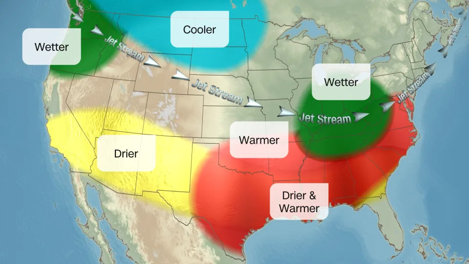
La Niña’s biggest influence is always on the jet stream – a river of air that storms flow through. The jet stream often shifts north during a La Niña winter, which pulls stormy weather out of the South and into more of the northern US.
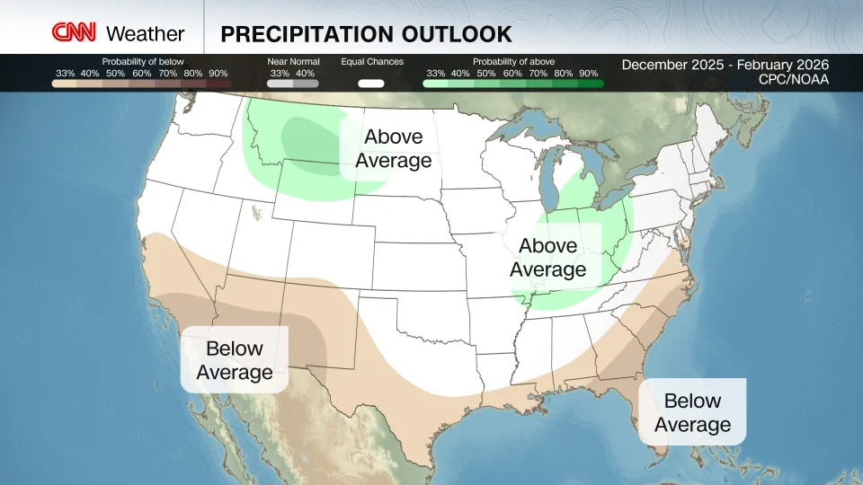
The Climate Prediction Center’s forecast for meteorological winter – December through February – definitely has La Niña’s fingerprints: A drier than normal winter is likely in many of the southernmost states with a couple pockets of the northern US expecting more precipitation than normal.
Snow lovers can’t celebrate just yet — more precipitation than normal doesn’t guarantee it will come as snow. Temperatures still have to be chilly enough both above and at the surface for snow to fall and stick, and that might not be the case this year.
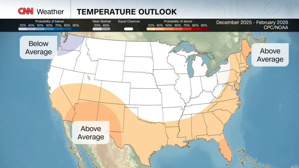
La Niña winters typically favor warmer than normal conditions in the South with cooler conditions for some northwest and north-central states.
True to form, the South is expected to be warmer than normal this winter, but so too are the Southwest, parts of the Rockies and nearly the entire Eastern Seaboard. That just shows that La Niña isn’t the only factor in play for the CPC’s forecasts.
Weak La Niña events tend to allow for more snow in the Northeast, but that above-average temperature forecast could impede dreams of a winter wonderland. A small slice of the Pacific Northwest is the only portion of the Lower 48 expected to be cooler than normal this winter. For the rest of the country, it’s a toss-up whether winter will end up warmer, cooler or close to normal.
Last winter wasn’t a record-warm one, like what the US experienced in 2023, but it was still much warmer than normal. It ended up warmer than 80% of all winter seasons since the late 1800s.
The idea of a typical winter is distorting as the world warms due to fossil fuel pollution: Winter has become the fastest-warming season for nearly 75% of the US. Snowfall is also declining around the globe as the climate changes.
For more CNN news and newsletters create an account at CNN.com


Comments