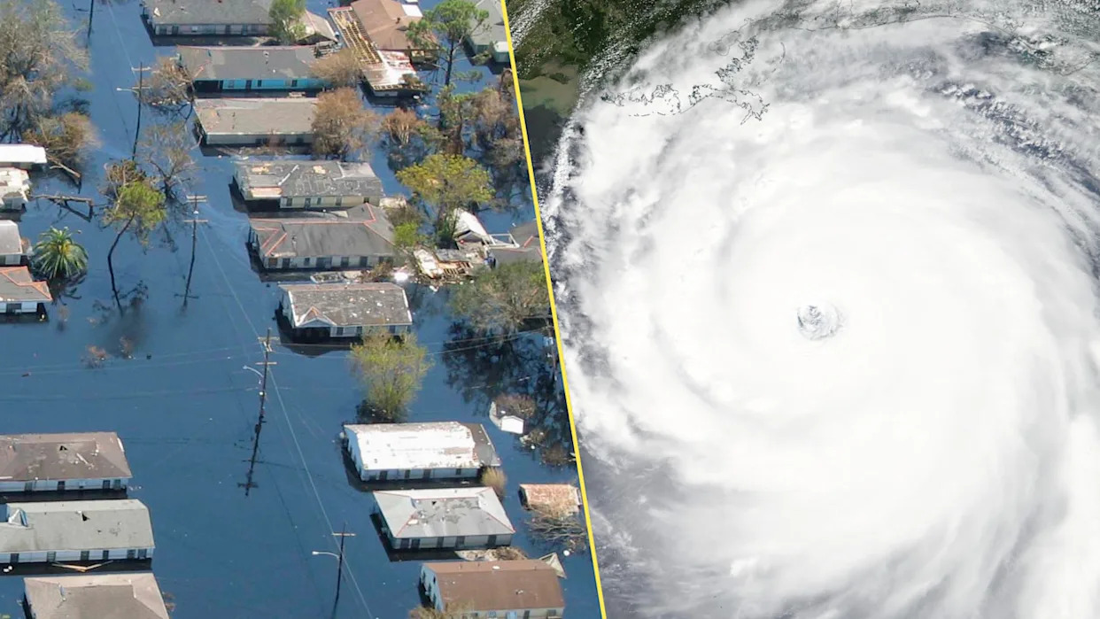
Hurricane Katrina pushed the sea 10 kilometres inland in some communities.
This wall of water turned a destructive cyclone into a generational tragedy along the northern Gulf Coast. More than 1,300 people died as Katrina’s fierce winds and unprecedented storm surge changed both coastlines and communities.
A confluence of factors contributed to Katrina’s legacy as one of the worst storms in living memory. But it all started with the hurricane’s unique storm surge.
DON'T MISS: What is a hurricane's storm surge—and why is it so dangerous?
Katrina was a classic peak-season hurricane
A weak disturbance that blew off the coast of Africa on Aug. 11 would grow into one of the most destructive hurricanes in modern history.
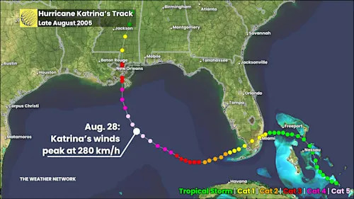
This disturbance formed into Tropical Storm Katrina over The Bahamas on Wednesday, Aug. 24. Katrina quickly intensified into a hurricane as it made landfall south of Miami, Florida, the following day. The system continued organizing as it moved west into the Gulf of Mexico.
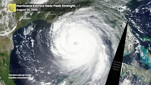
Faced with favourable conditions and very warm waters, Katrina underwent rapid intensification over the course of two days. This spell of strengthening brought the storm from a low-grade hurricane to a scale-topping Category 5 with maximum sustained winds of nearly 280 km/h.
Powerful hurricanes struggle to maintain peak strength for long. Katrina’s formidable structure began to stumble in the day leading up to landfall, triggering an eyewall replacement cycle that forced the storm’s winds to begin weakening.
Katrina remained a powerful storm by the time it hit Louisiana and Mississippi on Sunday, Aug. 29, roaring ashore as a Category 3 hurricane with 195 km/h winds.
DON'T MISS: Visit The Weather Network's hurricane hub to keep up with the latest on tropical developments in Canada and around the world
WATCH: Hurricane Katrina's intense landfall
Katrina’s was unique among hurricanes
Tropical systems aren’t uncommon on the northern Gulf Coast. But Katrina was as close to a worst-case scenario as we’ve seen in modern history.
Hurricane Katrina wasn’t just an intense storm—it was giant in size. At peak strength, Katrina’s tropical storm force winds extended 370 kilometres from the centre of the storm, with hurricane force winds stretching out 165 kilometres.
Even as the hurricane’s wind speeds weakened before landfall, this immense size essentially baked in Katrina’s destructive storm surge and waves as it approached the coast.
Katrina pushed a devastating storm surge inland
Storm surge is seawater pushed inland by the force of a storm’s strong and persistent winds. The depth and extent of surge depends on many factors, including the elevation and shape of the coastline.
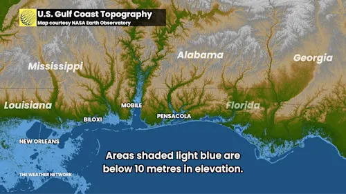
Katrina tracked over parts of southeastern Louisiana and southern Mississippi that largely lie below 10 metres in elevation, with vast swaths of coastline just above sea level.
This low-lying elevation, which extends several kilometres inland in many spots, contributed to the severity of the hurricane’s storm surge flooding. The concave shape of the coast, as well as local bays and inlets, also exacerbated the surge.
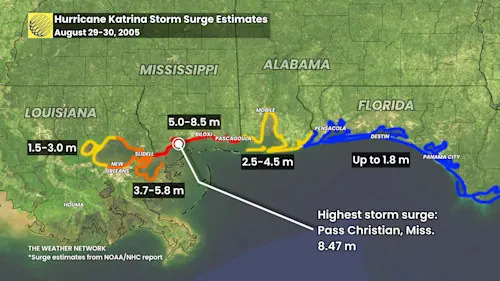
Southern Mississippi took the brunt of the surge, where the flooding reached 5.0 to 8.5 metres above ground level. The deepest surge occurred along the coast in Pass Christian, Mississippi, where experts measured a maximum water depth of 8.47 metres above ground level.
New Orleans devastated by the storm surge
The majority of Katrina’s fatalities occurred in New Orleans, which sits several metres below sea level. Sunken like a bowl between Lake Pontchartrain to the north and the Mississippi River to the south, the city relies on an intricate network of levees and pumps to keep water out.
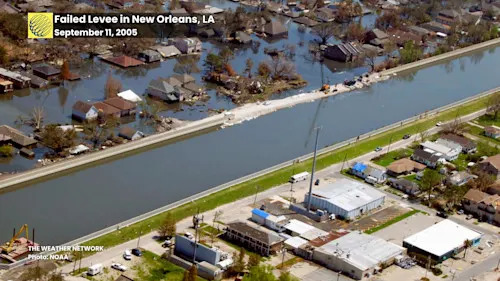
Katrina’s powerful winds pushed 4 to 5 metres of storm surge into Lake Pontchartrain and the Mississippi River, overtopping many of the levees protecting the city.
Water sloshing over the levees eroded the soil behind these protective earthen structures and caused many of them to fail, allowing floodwaters to surge through the broken levees into the low-lying city.
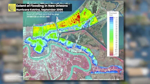
Water pouring through the failed levees flooded about 80 per cent of New Orleans in the hours and days after the storm.
Given the damage to levees and infrastructure throughout the city, it took 43 days for crews to completely clear the floodwaters out of the affected areas.
Header image created using graphics from NOAA.


Comments