Relief from sweltering temperatures has been dangled in front of the Florida Panhandle like a carrot on a stick after forecasts have steadily pushed milder temperatures further and further away.
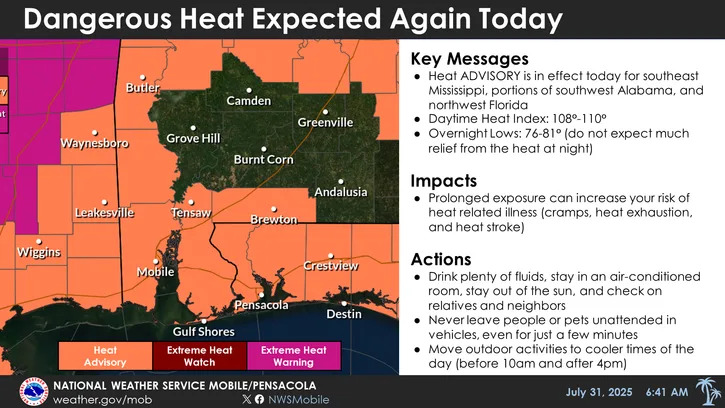
The National Weather Service has issued the fifth heat advisory in as many days for Escambia, Santa Rosa, and Okaloosa counties, which will be in effect until 6 p.m. on Thursday.
Pensacola is likely to see thunderstorms along with a high temperature reaching 93 degrees. The feels-like temperature is expected to hit as high as 109 degrees.
Friday and Saturday will bring similar highs, hovering around 92 degrees, before Sunday cools to about 90 and Monday dips to 89 degrees.
Weak cold front could drop temperatures slightly next week
The upper level ridging over the Pensacola area is forecast to give way to a trough starting on Friday and moving into early next week.
The trough will bring a weak cold front into the area over the weekend, with slightly milder temperatures expected to hit the area around Sunday. The trough also means instability, which will bring storms.
Floridians can expect a diurnal storm pattern, which means showers and storms will form over coastal waters in the morning and could spark “pulse” storms inland as temperatures peak. Pulse storms are quick-forming and short-lived thunderstorms.
What is a heat advisory? What to know about heat alerts
The National Weather Service uses a three-tiered heat alert system. Not all local offices use every heat-related product due to some places being more prepared to deal with intense heat than others.
Here's a general rundown of what each heat alert means:
Extreme heat warning — Take action! An extreme heat warning is issued when extremely dangerous heat conditions are expected or occurring. Avoid outdoor activities, especially during the heat of the day. If you must be outside, be sure to drink plenty of water and take frequent breaks in the shade. Stay indoors in an air-conditioned space as much as possible, including overnight. Check on family and neighbors.
Extreme heat watch — Be prepared! An extreme heat watch is issued when conditions are favorable for an extreme heat event but its occurrence and timing is still uncertain. Plan to suspend all major outdoor activities if a warning is issued. If you do not have air conditioning, locate the nearest cooling shelter or discuss staying with nearby family or friends who have air conditioning.
Heat advisory — Take action! A heat advisory is issued for dangerous heat conditions that are not expected to reach warning criteria. Consider postponing or rescheduling outdoor activities, especially during the heat of the day. If you must be outside, be sure to drink plenty of water and take frequent breaks in the shade. Stay in a cool place, especially during the heat of the day and evening.
Has July been hotter than normal in Pensacola?
July has been a toasty one in Pensacola, with temperatures averaging 1.4℉ hotter across the month so far, according to NOAA's latest climate data.
Here's a look at July's stats so far:
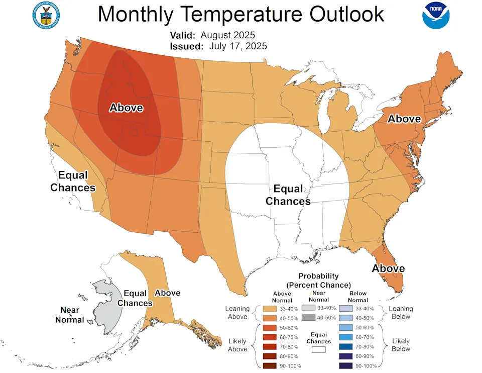
How hot will August be in Florida?
NOAA's Climate Prediction Center believes that the majority of Florida is likely to see above-normal temperatures in August. The Pensacola area stands out as the only part of the state that has equal chances of seeing below- or above-normal temperatures.
The map of areas impacted by the current heat dome is a near inversion of NOAA's monthly temperature map, which was issued on July 17. The odds could swing toward Pensacola seeing a warmer-than-normal August should the dome stick around.
Weather radar for Pensacola, Milton, Fort Walton Beach, Destin
Heat index alert: Weather watches and warnings issued in Florida
This article originally appeared on Pensacola News Journal: Heat wave: More dangerous heat expected in Florida Panhandle


Comments