Dangerous torrential rainfall and flash flooding are underway in the mid-Atlantic and Northeast Thursday with millions at risk along the Interstate 95 corridor. It’s shaping up to be another serious flood event in a summer that’s been full of them.
Heavy storms developed in the afternoon and will last through the evening. Some could dump several inches of rain in a few hours, flooding roads and threatening public transit during the busy afternoon and evening commute.
Flash flood warnings were active in parts of Pennsylvania, New Jersey, Maryland and Virginia by mid-afternoon with more drenching storms to come. There have already been reports of flooded roads and stranded vehicles in Maryland and Pennsylvania, according to the National Weather Service and local officials.
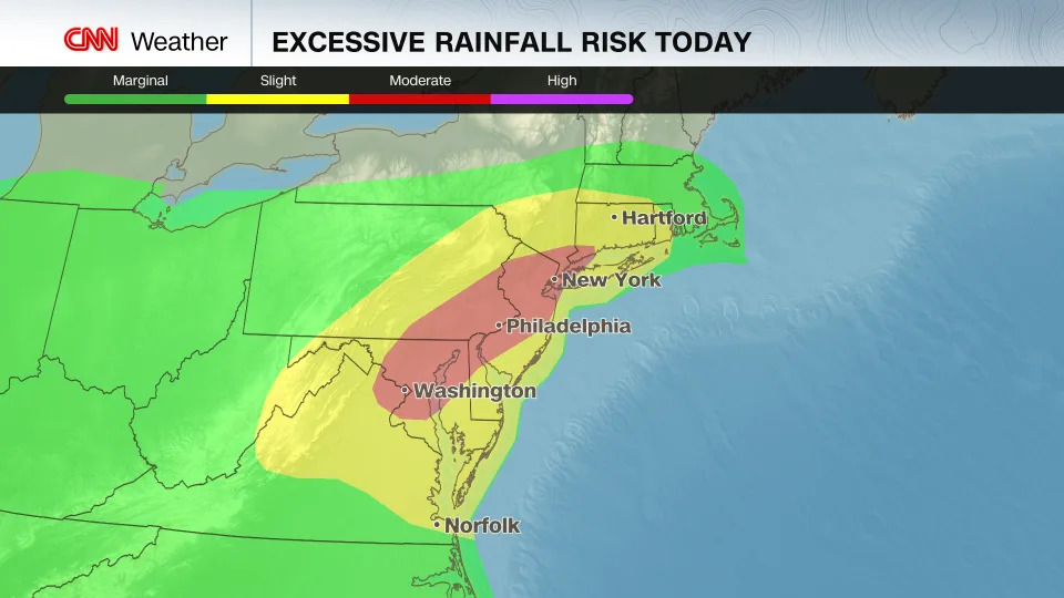
The Weather Prediction Center has issued a Level 3 of 4 risk for flooding rain from Washington, DC, to New York City and the southernmost part of Connecticut. This threat level means numerous flash floods are likely, some of which could threaten life and property in vulnerable urban areas. Philadelphia and Baltimore are also included in this risk area.
A Level 2 of 4 risk of flash flooding is in place for a broader area extending inland from Virginia Beach up through southern New England, including the rest of Connecticut.
New Jersey is under a state of emergency due to the potential for intense rainfall and flash flooding, according to a news release from acting Gov. Tahesha Way.
“I urge all New Jerseyans to remain alert, follow all safety protocols, and monitor the proper channels for the duration of these storms,” Way said in the release. “Residents should remain off the roads and indoors unless absolutely necessary.”
Travel disruptions could be severe as the heaviest rain may fall during the evening commute. Subways could also see serious flooding, as New York saw earlier this month, when intense rainfall in the span of hours sent water gushing onto platforms and into subway cars.
Some storms are expected to train, or continue moving or redeveloping over the same areas, raising rainfall totals considerably. A few locations could get up to 8 inches of rain in a short amount of time, though exactly where the most intense storms will set up within the Level 3 of 4 area remains uncertain.
The rain is due to a cold front that is breaking a long-lasting, punishing heat dome that has been keeping the East sweltering during the day and simmering at night.
After a summer of frequent rain and flooding, the water simply has no place to go. And even if the region wasn’t soaked, extreme rainfall rates up to 3 inches per hour could overwhelm areas that typically drain well. Cities often struggle to handle heavy rain as pavement and asphalt keep water from soaking into the ground and instead head for drains that are prone to clogging or simply incapable of handling the volume of water.
“This type of setup carries the potential for very rapid rises on small streams and dangerous flooding in city streets,” the WPC said. “Residents in the mid‑Atlantic should ensure they have reliable ways to receive warnings throughout the day and into Thursday night.”
Flash floods are most common in summer, as warmer air can hold more moisture and intense daytime heat helps fuel potent storms. But overwhelming rainfall is becoming more prevalent due to climate change, as rising global temperatures drive weather toward extremes. Hourly rainfall rates have grown heavier in nearly 90% of large US cities since 1970, according to a study from the nonprofit research group Climate Central.
Rainfall across the mid-Atlantic and Northeast has already been above normal this summer — especially in parts of eastern Pennsylvania, central New Jersey, northern Maryland, and the DC suburbs — leaving soils saturated and primed for rapid runoff and flooding even without extreme amounts of rain.
Flood watches are in effect for the at-risk portion of the I-95 corridor and surrounding areas, including Washington, DC, Baltimore, Philadelphia and New York City. Most of these watches will remain in place into Friday morning.
Nearly all of New Jersey is in the risk area. The state has been slammed by flooding this summer, including when at least two people were killed two weeks ago. The increased risk also includes parts of Virginia that have flooded multiple times this season.
Flooding can be extremely dangerous at night, when it’s harder to see water covering roads. “If you encounter a flooded roadway, turn around and find another route,” the National Weather Service advises. “It only takes six inches of fast‑moving water to knock over an adult and just 12 inches to sweep away most vehicles.”
Less than two weeks ago, on July 19, the National Weather Service issued a flash flood emergency — the highest level of flood alert — for the Washington, DC, area with rainfall rates of 1 to 2 inches in 30 minutes raising rivers and sending water over roadways. Dozens of people had to be rescued from floodwaters after heavy rain struck parts of Virginia, Maryland and Washington, DC.
The flood risk shifts south into the Carolinas and part of Georgia on Friday, more states all too familiar with serious flooding this summer. Tropical Storm Chantal’s flooding rainfall killed at least one person in North Carolina in early July.
CNN Meteorologist Mary Gilbert contributed to this report.
For more CNN news and newsletters create an account at CNN.com


Comments