The Colorado River is in trouble: Not as much water flows into the river as people are entitled to take out of it. A new idea might change that, but complicated political and practical negotiations stand in the way.
The river and its tributaries provide water for about 5 million acres of cropland and pasture, hydroelectric power for millions of people, recreation in the Grand Canyon, and critical habitat for fish and other wildlife. Thirty federally recognized Native American tribes assert rights to water from the Colorado River system. It is also an important source of drinking water for cities within the Colorado River Basin, including Phoenix, Tucson and Las Vegas, and cities outside the basin, such as Los Angeles, San Diego, Salt Lake City, Denver and Albuquerque.
The seven Colorado Basin states have been grappling with how to deal with declining Colorado River supplies for a quarter century, revising usage guidelines and taking additional measures as drought has persisted and reservoir levels have continued to decline. The current guidelines will expire in late 2026, and talks on new guidelines have been stalled because the states can’t agree on how to avoid a future crisis.
In June 2025, Arizona suggested a new approach that would, for the first time, base the amount of water available on the river’s actual flows, rather than on reservoir level projections or historic apportionments. While the proposal has been praised as offering “a glimmer of hope,” coming to agreement on the details presents daunting challenges for the Colorado Basin.
The Colorado River Compact
The 1922 Colorado Compact divided the 250,000-square-mile Colorado River Basin into an Upper Basin – which includes parts of Colorado, New Mexico, Utah and Wyoming, as well as the northeastern corner of Arizona – and a Lower Basin, encompassing most of Arizona and parts of California and Nevada. The compact apportions each basin 7.5 million acre-feet of water from the river each year. An acre-foot of water is enough to cover 1 acre in water 1 foot deep, which amounts to approximately 326,000 gallons. According to a 2021 estimate from the Arizona Department of Water Resources, 1 acre-foot is sufficient to supply 3.5 single-family households in Arizona for one year.
Anticipating a future treaty with Mexico for sharing Colorado River water, the compact specified that Mexico should be supplied first with any surplus available and any additional amount needed “borne equally” by the two divisions. A 1944 water-sharing treaty between Mexico and the U.S. guarantees Mexico at least 1.5 million acre-feet of Colorado River water annually.
The compact also specified that the Upper Basin states of Colorado, New Mexico, Utah and Wyoming “will not cause the flow of the river … to be depleted below an aggregate of 75,000,000 acre-feet for any period of 10 consecutive years.”
The Lower Basin states of Arizona, California and Nevada contend that this provision is a “delivery obligation,” requiring the Upper Basin to ensure that over any 10-year period, a total of at least 75 million acre-feet flows to the Lower Basin.
By contrast, the Upper Basin states contend that the language merely creates a “non-depletion obligation” that caps their collective use at 7.5 million acre-feet per year in times when additional use by the Upper Basin would cause less than 75 million acre-feet to be delivered to the Lower Basin over a 10-year period.
This disagreement over the compact’s language is at the heart of the differences between the two basins.
A small source area
Nearly all of the water in the Colorado River system comes from snow that falls in the Rocky Mountains in the Upper Basin. About 85% of the Colorado Basin’s flows come from just 15% of the basin’s surface area. Most of the rest of the basin’s lands are arid or semi-arid, receiving less than 20 inches of precipitation a year and contributing little to the flows of the Colorado River and its tributaries.
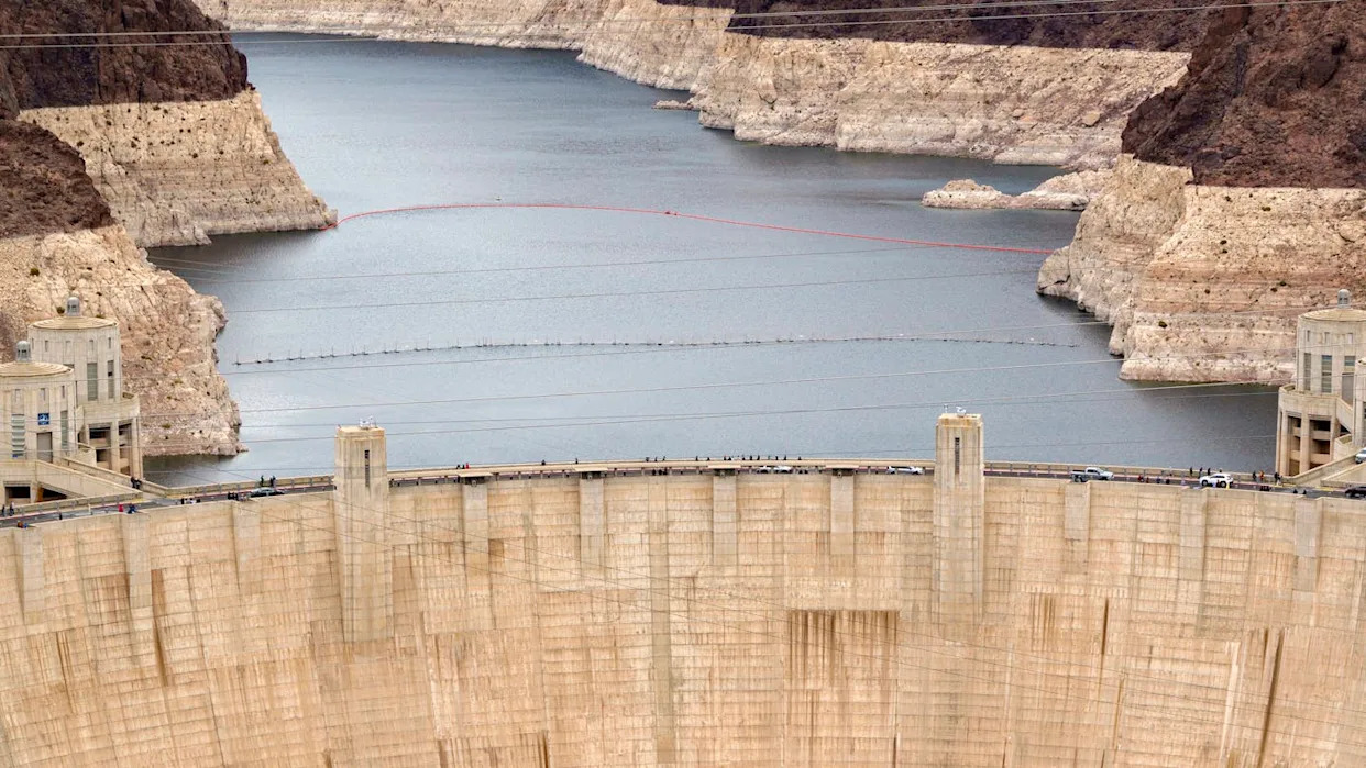
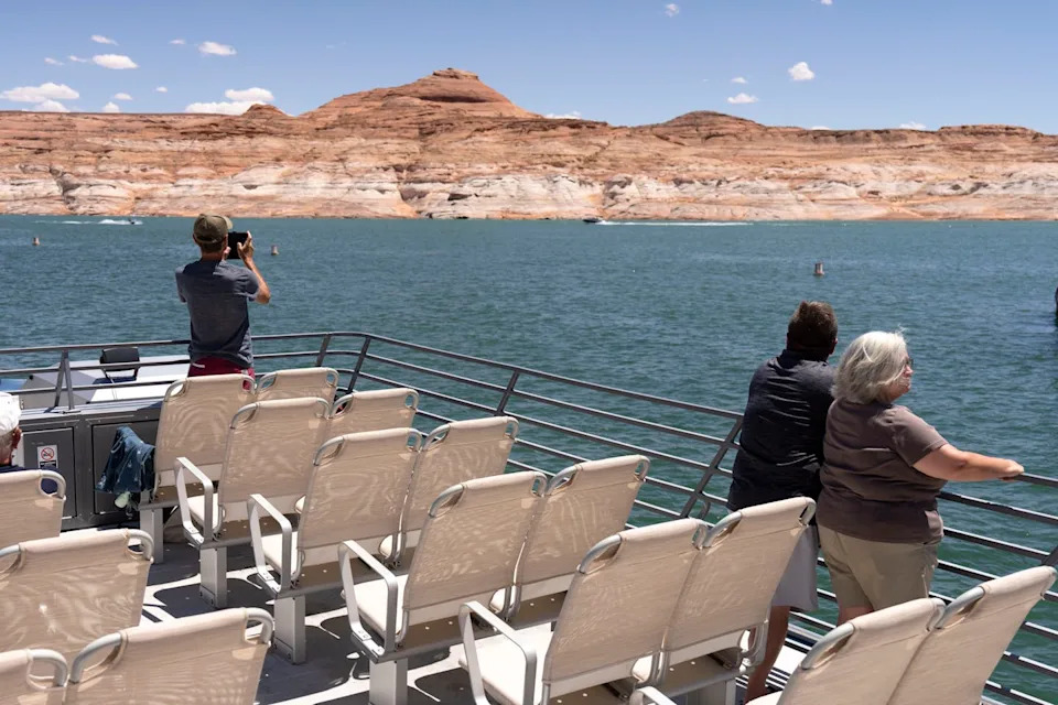
Rain and snowfall vary dramatically from year to year, so over the course of the 20th century, the Colorado Basin states – with the assistance of the U.S. Bureau of Reclamation, the agency of the Department of the Interior responsible for operating federal water and power projects in the U.S. West – developed a complex system of reservoirs to capture the extra water in wet years so it could be available in drier years. The most notable reservoirs in the system are Lake Mead, impounded by Hoover Dam, which was completed in 1936, and Lake Powell, impounded by Glen Canyon Dam, completed in 1966.
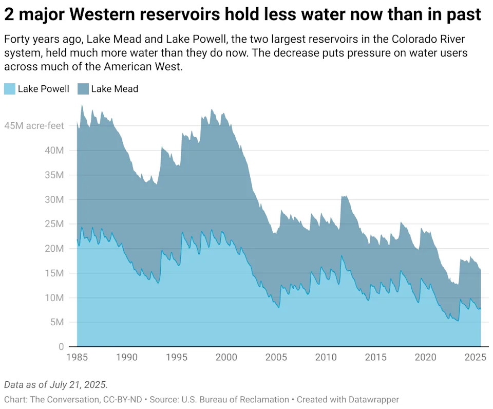
Over the past 25 years, the quantity of water stored in Lake Mead and Lake Powell has declined significantly. A primary driver of this decline is a lengthy drought likely amplified by climate change: One study estimated that the region may be suffering its driest spell in 1,200 years.
But human errors are also adding up. The Colorado Compact’s original negotiators made unrealistically optimistic assumptions about the river’s average annual flow – perhaps knowingly. In their book “Science be Dammed,” Colorado River experts Eric Kuhn and John Fleck document how compact negotiators willfully or wishfully ignored available data about the river’s actual flows. Kuhn and Fleck argue the negotiators knew it would be decades before demand would exceed the river’s water supply, and they wanted to sell a big vision of Southwestern development that would merit massive federal financing for reservoirs and other infrastructure.
In addition, the current Colorado River system accounting does not factor in the roughly 1.3 million acre-feet of water lost annually from Lake Mead due to evaporation into the air or seepage into the ground. This accounting gap means that under normal annual releases to satisfy the apportionments to the Lower Basin and Mexico, Lake Mead’s water level is steadily declining.
Stabilization efforts
The seven Colorado River states and Mexico have taken significant steps to stabilize the reservoirs. In 2007, they agreed to new guidelines to coordinate the operations of Lake Mead and Lake Powell to prevent either reservoir from reaching catastrophically low levels. They also agreed to reduce the amount of water available to Arizona and Nevada depending on how low Lake Mead’s levels go.
When the 2007 guidelines proved insufficient to keep the reservoir levels from declining, the Colorado Basin states and Mexico agreed in 2019 to additional measures, authorizing releases from Upper Basin reservoirs under certain conditions and additional cuts to water users in the Lower Basin and Mexico.
By 2022, projections for the reservoir levels looked so dire that the states started negotiating additional near-term measures to reduce the amount of water users withdrew from the river. The federal government helped out, too: $4 billion of Inflation Reduction Act funding has helped pay the costs of water-conservation measures, primarily by agricultural districts, cities and tribes.
These reductions are real. In 2023, Arizona, California and Nevada used only 5.8 million acre-feet of Colorado River water – their lowest combined annual consumption since 1983. The Lower Basin’s total consumption in 2024 was slightly higher, at 6.09 million acre-feet.
A new opportunity?
With the 2007 guidelines and additional measures expiring in 2026, the deadline for a new agreement looms. As the Colorado River states try to work out a new agreement, Arizona’s new proposal of a supply-driven approach offers hope, but the devil’s in the details. Critical components of that approach have not been ironed out – for instance, the percentage of the river’s flows that would be available to Arizona, California and Nevada.
If the states can’t agree, there is a chance that the secretary of the Interior, acting through the Bureau of Reclamation, may decide on his own how to balance the reservoirs and how much water to deliver out of them. That decision would almost certainly be taken to court by states or water users unhappy with the result.
And the Lower Basin states have said they are fully prepared to go to court to enforce what they believe to be the Upper Basin’s delivery obligation, which, the Upper Basin has responded, it is prepared to dispute.
In the meantime, farmers in Arizona’s Yuma County and California’s Imperial County cannot be sure that in the next few years they will have enough water to produce winter vegetables and melons for the nation. The Colorado River Basin’s municipal water providers are worried about how they will meet demands for tap water for homes and businesses. And tribal nations fear that they will not have the water they need for their farms, communities and economies.
This article is republished from The Conversation, a nonprofit, independent news organization bringing you facts and trustworthy analysis to help you make sense of our complex world. It was written by: Sarah Porter, Arizona State University
Read more:
Sarah Porter is the Director of the Kyl Center for Water Policy, part of Arizona State University's Morrison Institute for Public Policy. In 2021, the Kyl Center for Water Policy received a grant from the Walton Family Foundation to develop a data visualization tool showing how Colorado River shortage will impact cities, tribes and agricultural districts in Arizona.


Comments