Two tropical storms are spinning over the eastern and central Pacific Ocean, with one set to graze Mexico, while the other takes a rare track north of Hawaii in the coming days.
Ivo to graze western Mexico
Tropical Storm Ivo will strengthen and is forecast to become a hurricane on Friday. It will parallel the coast of Mexico before eventually drifting out to sea.
The heaviest rain and wind from Ivo is expected to fall over the Pacific Ocean. However, some rain will skirt the coast of Mexico as Ivo continues to move along just offshore.
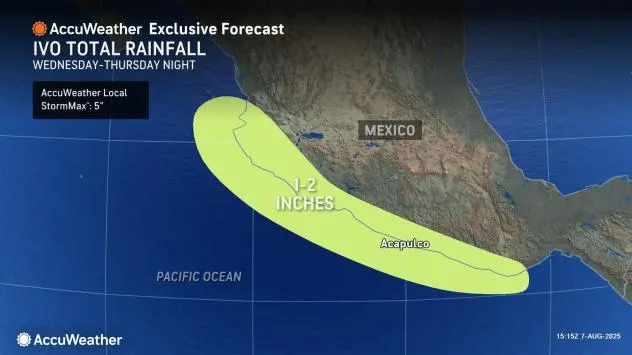
"However, enough rain can fall along the immediate coasts and the nearby hills and escarpments to lead to flash flooding and mudslides into Friday," AccuWeather Lead Hurricane Expert Alex DaSilva said. "A large swath of 1-2 inches of additional rain is expected from western Guerrero to southern Nayarit, Mexico. The heaviest rain will be closest to the coast with an AccuWeather Local StormMax™ of 5 inches."
Factoring in the storm's intensity, distance from the coast and rain in store, Ivo is less than one on the AccuWeather RealImpact™ Scale for Hurricanes in Mexico.
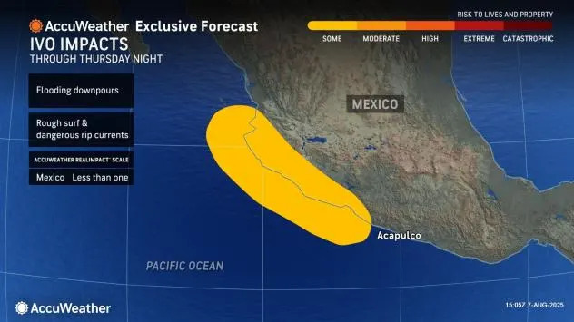
"Ivo will continue to bring dangerous seas, rough surf and strong rip curents to the coast of Mexico into this weekend," DaSilva said.
Henriette swirling into the central Pacific
Tropical Storm Henriette is about 1,600 miles east of Honolulu and will stay far enough away from Hawaii to avoid direct impacts, but there will be some indirect effects.
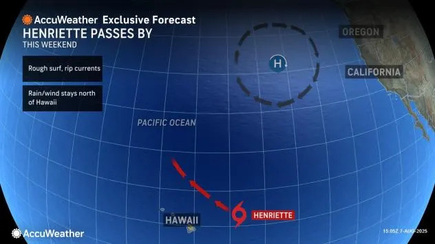
"Henriette is struggling at the moment, but if it survives over the next couple of days, it will bring some increased seas and surf and locally strong rip currents to the Hawaiian Islands from later this weekend to early next week as it passes a few hundred miles to the northeast and north," DaSilva said.
There is a chance a weak plume of tropical moisture may develop to the south of Henriette as it passes by to the north, which could enhance shower activity.
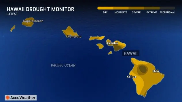
The islands could use significant rain as conditions range from abnormally dry to extreme drought. The lack of rain has left brush in many areas quite dry and prone to wildfires.
Henriette could disrupt the stiff breezes associated with the northeast trade winds. However, local breezes and dry conditions can still be enough to allow for a quick ignition and rapid spread of wildfires in the region.
It is possible that Henriette may become a hurricane as it moves well north of the islands early next week. Typically, tropical storms struggle over cooler waters near and north of Hawaii.
With the wave of enhanced tropical development that slowly circles the globe, known as the Madden-Julian Oscillation (MJO), shifting into the Atlantic in the coming days and weeks, new development in the eastern and central Pacific may be limited for a time.
Want next-level safety, ad-free? Unlock advanced, hyperlocal severe weather alerts when you subscribe to Premium+ on the AccuWeather app. AccuWeather Alerts™ are prompted by our expert meteorologists who monitor and analyze dangerous weather risks 24/7 to keep you and your family safer.


Comments