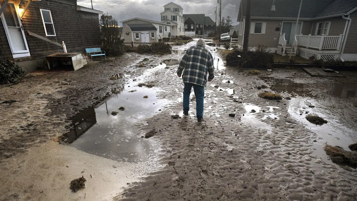
Early last spring, while still cleaning up the wreckage of devastating winter storms, southern Maine towns began drafting new rules governing how they’d rebuild or develop on stretches of land that were widely inundated months before.
The process coincided with the adoption of new federal flood maps and is required by the Federal Emergency Management Agency for participation in the National Flood Insurance Program.
After years of back-and-forth between FEMA and local officials, the agency finalized its first flood map updates for Cumberland and York counties in decades.
The maps’ finalization last summer meant local officials had to update their floodplain ordinances to FEMA standards or risk their residents losing out on federal flood insurance — often a requirement for homeowners with government-backed mortgages who live in FEMA flood zones.
While municipalities could simply adopt boilerplate language that the Maine Floodplain Management Program provides towns based on their local flood threat (i.e. coastal or riverine), towns also had the opportunity to fine-tune or strengthen their floodplain rules further.
One way to do that is by requiring heightened standards if new developments or significant renovations occur inside regulated flood zones.
Municipalities, for example, could require that the lowest floor of a new development be built higher than the one foot above flood level that FEMA recommends, giving future homes more protection from sea level rise, which FEMA flood maps don’t account for.
That’s the path that Scarborough’s town council took last year. Their updated floodplain ordinances require anyone building a new development or making repairs worth more than 50 percent of a building’s value to raise the lowest floor two feet above flood level.
Brian Longstaff, Scarborough’s zoning administrator, said that he was a little hesitant about the proposal at first when considering the challenges it could pose to homeowners who were already in compliance with the FEMA minimum.
“It was a little bit of a big bite, I thought, but in the end, it makes sense,” Longstaff told The Maine Monitor, adding that the town is conducting a vulnerability assessment and its projections for future sea level rise show local flood risks growing down the line.
“I’m looking at the vulnerability assessment, the picture of risk maps… and there are some areas of Scarborough the projections are pretty scary,” Longstaff said.
Down the coast in Wells, town officials took a different approach. They kept the one-foot minimum elevation requirement in flood zones but expanded the criteria that triggers it.
Whereas Scarborough requires repairs or remodels that are worth more than 50 percent of a building’s value and completed within one year to be elevated to its two-foot minimum, Wells tracks the cumulative value of such projects — adding up project costs over a multi-year period to determine when an elevation change is required.
That’s an effective way to close a common loophole used to get around similar ordinances according to Sue Baker, coordinator of the Maine Floodplain Management Program. (The Wells code enforcement director and town planner could not be reached for comment by publication.)
“There are some people that will just piecemeal their projects so that they stagger them out over a number of years, so that they don't ever trigger the substantial improvement rule,” Baker said. “What I think is bad about that is now you're putting thousands and thousands of dollars into a building, but you haven't changed the risk.”
Scarborough considered similar language during the town’s ordinance development, but ultimately town officials didn’t adopt it, according to Longstaff. As a certified floodplain manager, he said he carefully evaluates projects in flood zones and can typically reach an understanding with the applicant about flood risks and how to mitigate them, though calculating cumulative improvements is “'a great idea to do over a reasonable period.”
The deadly floods that devastated Central Texas last month provide a stark example of what happens when flood zone development regulations are absent or unenforced. Camp Mystic, the summer camp where 27 campers and counselors died, was built in a high-risk flood zone.
In rural Texas, there are few regulatory powers afforded to county governments over flood zones and many communities exist outside of the jurisdiction of municipal ordinances, according to the Texas Tribune. In Maine, meanwhile, unorganized communities are overseen by the state Land Use Planning Commission, and county hazard mitigation initiatives are widespread.
Outside of southern Maine, Baker said the state is developing updated flood maps for multiple watersheds and pursuing new initiatives through the recently formed State Resilience Office and Office of Community Affairs.
But with the vulnerabilities exposed in last year’s storms and climate change's intensification of sea level rise and heavy precipitation events, it only makes sense to elevate and move back from flood-ravaged areas whenever possible, according to Baker.
“I heard a good quote once upon a time,” Baker said. “‘There's going to be retreat. The question is whether… it's going to be managed or unmanaged.’”


Comments