The Brief
Friday in Central Florida starts with scattered showers and storms, especially along the coast and west of I-95, with up to an 80% chance of rain and potential flooding.
A brief dry window will occur late morning to early afternoon before storms return in the late afternoon, followed by isolated showers overnight with mild temperatures in the mid-70s.
This weekend will bring continued afternoon storms and a slight cooldown, with a more typical scattered rain pattern and rising temperatures expected next week.
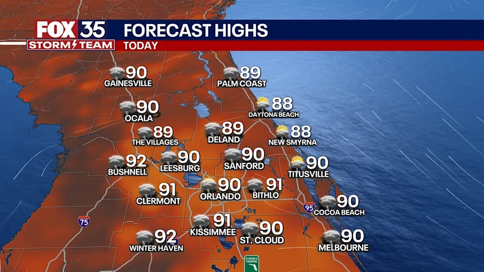
ORLANDO, Fla. - Central Florida starts Friday with scattered storms, particularly along the coast and west of Interstate 95.
Here’s what to expect today and over the weekend.
What will the weather look like today?
What to expect
We begin our Friday morning with scattered showers and storms across Central Florida. For this round in particular, the highest chances will be four our coastal counties.
Timeline
From 10am-noon, we'll see a window of dry-time that will last a few hours ahead of additional rounds that will begin around 4-5pm.
Plan for up to an 80% chance of showers and storms. With this round, areas west of I-95 have the highest chances of rain.

Potential storm threats
With the amount of heavy rain and moisture at play, flooding and flash flooding will be possible. Gusty winds and frequent lightning will be impacts felt as well.
It's important to note that this morning's round of showers and storms could use up a lot of the moisture needed for this afternoon. This could mean lower and more limited chances of rain.
CLICK TO DOWNLOAD THE FOX LOCAL APP
Regardless, it's a good idea to keep the rain gear handy and stay close to the forecast.
What will the weather look like tonight?
A few lingering showers and storms are possible into the overnight. These will remain fairly scattered to isolated before eventually dissipating early tomorrow morning. Temperatures will be warm and muggy, but seasonable. Lows will fall into the mid 70s.
What will the weather look like this weekend?
Looking ahead
As we move into the weekend, high chances of heavy afternoon rain and storms will persist. An isolated strong storm or two can't be ruled out, with gusty winds, heavy rain, and frequent lightning, once again, being the main threats. If you have weekend plans, your best chances of seeing dry time will be during the first half of the day, because shower and storm chances will be on the increase during the afternoons.

A slight reprieve from the heat also arrives this weekend, with highs around the low 90s. Next week, a more typical pattern sets up. This means more sea-breeze-driven scattered showers and storms will be likely. With slightly lower chances of rain, temperatures will heat back up into the mid-90s by midweek.

SIGN-UP FOR FOX 35'S BREAKING NEWS, DAILY NEWS NEWSLETTERS
The Source
This story was written based on information shared by the FOX 35 Storm Team on August 8, 2025.


Comments