A slow-moving frontal boundary is setting the stage for a significant flood threat this weekend across parts of the Upper Mississippi River Valley, with the FOX Forecast Center warning that multiple rounds of heavy rainfall could lead to dangerous flash flooding.
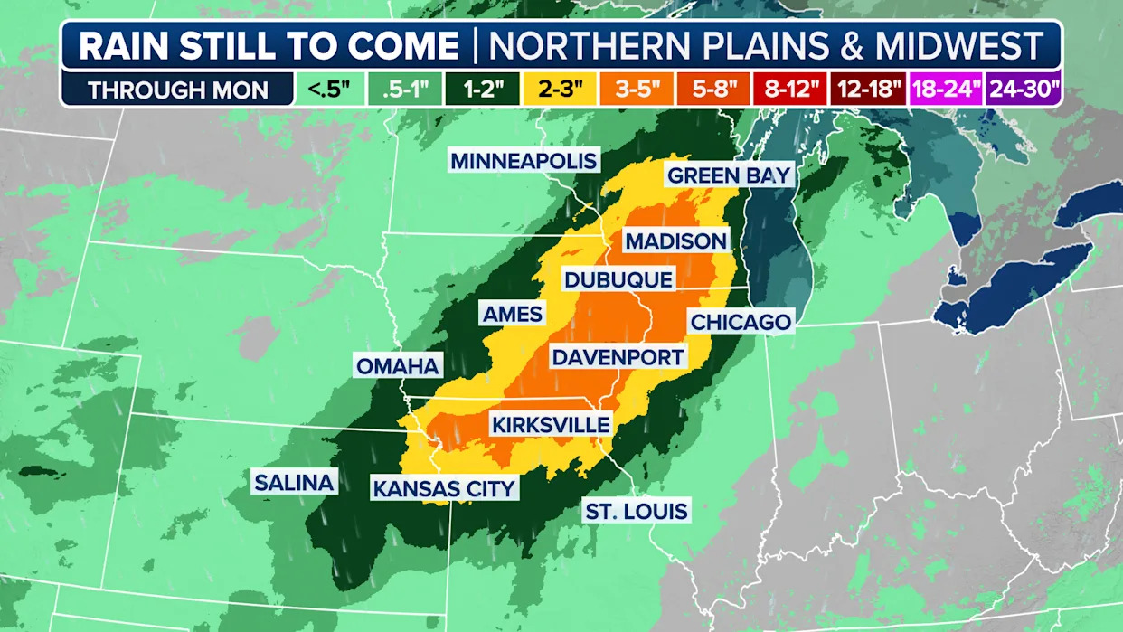
Forecasters are most concerned for communities between Des Moines, Iowa and Chicago, where hourly rainfall rates could reach 1-3 inches with an expected weekend total approaching 9 inches of precipitation in some areas.
Given recent rounds of showers and thunderstorms in the Midwest, NOAA's Weather Prediction Center has issued a Level 3 out of 4 on its excessive rainfall risk gauge for parts of southern Wisconsin, northwest Illinois and portions of Iowa.
"This is going to be one of the things we’re watching most closely here on FOX Weather through the weekend," said FOX Weather meteorologist Ian Oliver. "There was a massive upgrade to the flash flood threat into the weekend for Saturday into Sunday morning. Madison, Wisconsin, up to almost Sheboygan, arcing all the way back to Des Moines, Iowa."

Watch: Tree Crashes Into Alligator Lagoon In Florida
Due to the threat, communities such as Wisconsin Dells, Madison and outside of Sheboygan in Wisconsin are under a Flood Watch, which is expected to be in effect until at least Monday.
"Excessive runoff may result in flooding of rivers, creeks, streams, and other low-lying and flood-prone locations. You should monitor later forecasts and be prepared to take action should Flash Flood Warnings be issued," National Weather Service meteorologists warned.
Forecasters remind residents that just 6 inches of moving water can knock an adult off their feet, while a foot of floodwater can cause a vehicle to stall and float away.
Dubuque, Iowa, which was put under a Flash Flood Emergency in June, is again in the path of potentially significant rainfall totals.
"Dubuque is a place that has dealt with terrible flash flooding…and now you’re dealing with at least the potential for something like that again," Oliver stated.
Shipwrecks Dating Back To 1700S Uncovered Along North Carolina Shoreline
Some of the thunderstorms are expected to turn severe with gusty winds and isolated tornadoes, but the greatest impacts are impacted to stem from the multiple rounds of heavy rainfall.
The flood threat is expected to persist at least through Monday, as the boundary in essence rains itself out over the region.
Of concern will be how much rainfall occurs over agricultural areas that are busy growing vegetables such as beans, cucumbers and corn, as the harvesting season could be in full swing in just a matter of weeks.
Officials urge residents in the alerted region to continue to monitor forecasts closely and be prepared for the issuance of Flood Warnings and even Flood Emergencies, should the need arise.
Original article source: Flood threat upgraded for Upper Mississippi River Valley as sluggish front triggers multiple rounds of rain


Comments