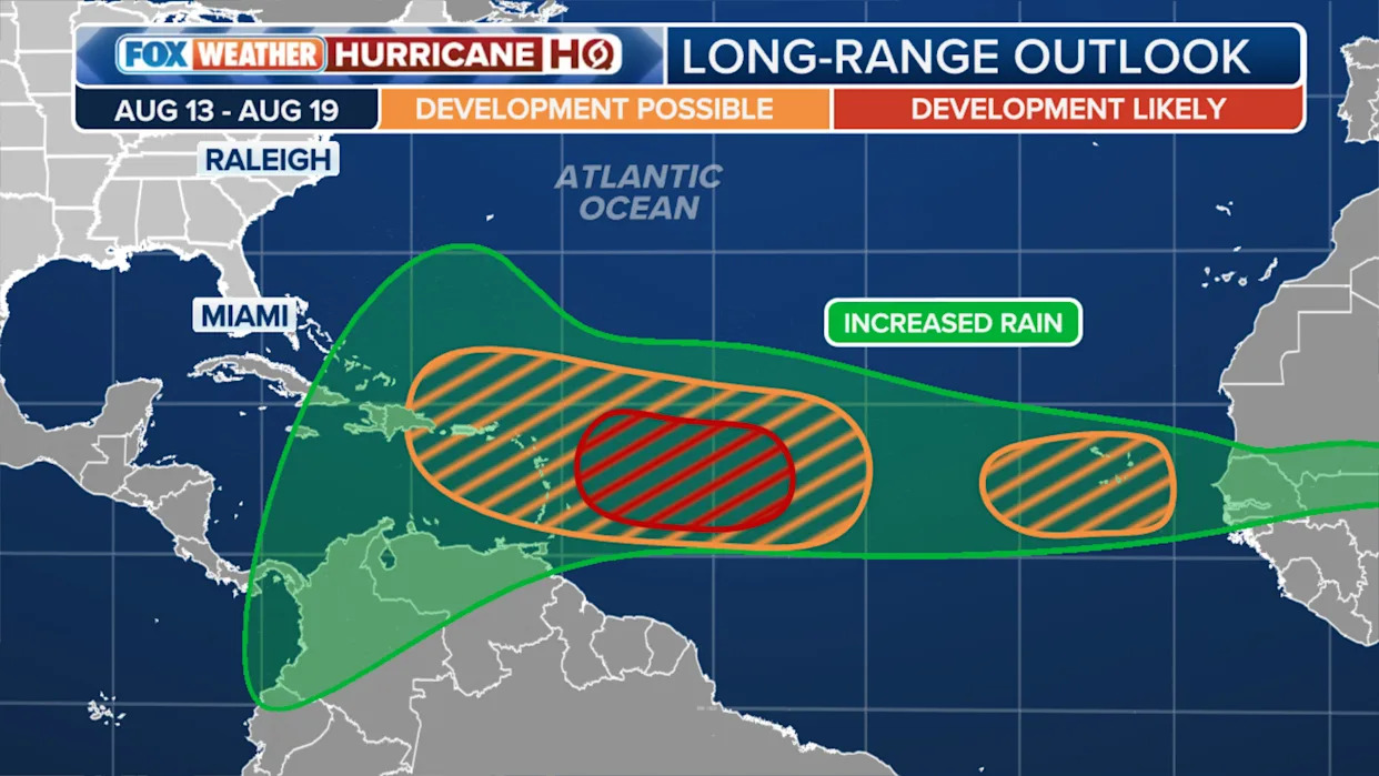
MIAMI -- Just as the disturbance tagged Invest 96L continues its journey into irrelevance in the open Atlantic Ocean, a new tropical wave just emerging off the western coast of Africa has caught the attention of the National Hurricane Center as a fresh area to watch for future development.
So far, the NHC has already doubled the odds of development to a 40% chance of the wave developing into a tropical depression or storm over the next 7 days, from its initial 20% chance given just Friday night.
"Environmental conditions appear favorable for gradual development of this system, and a tropical depression could form by the middle to latter portion of next week while it moves west-northwestward at 15 to 20 mph across the eastern and central tropical Atlantic," the NHC wrote early Saturday morning in announcing its newest item on its tropical weather outlook.
But long-range forecast models suggest the storm could find favorable conditions for development in the days beyond next week as it gets closer to North America.

Unlike Invest 96L, this storm is starting its trek off Africa a bit farther to the south, which means it will likely avoid dry, dusty Saharan Desert air that can keep storms from developing and had dogged 96L's development. 96L is now heading north into open waters, its chances of developing into a tropical system waning further, and is no threat to land.
Noaa Sticks With Prediction Of Above-average 2025 Atlantic Hurricane Season As Peak Nears
But computer forecast models are in agreement that this new disturbance will head west across the Atlantic, possibly reaching the Caribbean islands by late next week or that weekend, according to the FOX Forecast Center.
As it moves, it too will face some challenges from dry air and dust over the Atlantic. However, as it gets closer to the Caribbean, the atmosphere is expected to become more favorable for it to strengthen.
The western Atlantic, including the Gulf of Mexico, the Caribbean, and waters off the southeast U.S. continues to harbor the basin’s warmest ocean temperatures, the FOX Forecast Center says. Any systems that manage to reach those warmer pools of water would have a higher ceiling for intensification.
As the system is approaching the vicinity of the (Caribbean) islands, the atmospheric pattern is forecast to become more conducive to the system strengthening," said FOX Weather Hurricane Specialist Bryan Norcross. "Since a system’s intensity and track are often related – a stronger system is normally more likely to turn north – we’ll have to see how quickly this one organizes as it moves west. The more organized it gets, the better the forecasts are likely to be."
But Norcross warned that despite rampant social media speculation showing some forecasts 12-14 days out indicating a potential major storm near the US, there is no forecast skill in predicting storms that far out.
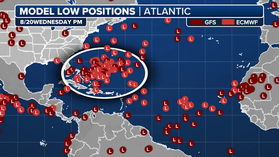
"Despite what you might see posted on social media, there is nothing more to know," Norcross said. "All long-range forecasts for a system that has not even begun to develop are subject to large errors and are likely to change many times. Posts showing landfall in the United States are not worth your attention and are only there to cause angst."
But the end of August looks to keep forecasters busy. Norcross says two or three other disturbances are forecast to move off Africa behind this one.
"They will all bear watching, of course," he said. "There is nothing more to say at this point."
Original article source: New tropical wave emerging off Africa now area to watch for future development as 96L spins into irrelevance


Comments