SALT LAKE CITY (ABC 4) – Happy Wednesday, Utah! Building high pressure overhead today will allow for peak heating along the Wasatch Front today!
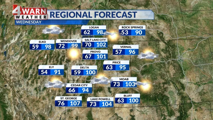
You can expect sunny skies statewide with a spike in temperatures. This time of year, St. George holds on to the heat with an average of 101 degrees, while Salt Lake typically sees highs around 93 degrees. We could see our sixth triple digit day of the season today in Salt Lake City with numbers climbing above 100 degrees.
Southern Utah will be hot yet again with St. George matching Tuesday’s high of 107 degrees. With the apex of our ridge over Utah today, we do have an “Extreme Heat Warning” that goes into effect for the Glen Canyon area at noon. This warning will remain in effect until 9pm with temperatures expected to get to 104 degrees.
With this area of high pressure overhead, we will see westerly winds increase and that’s going to contribute to fire danger. Today, a Red Flag Warnings go into effect at noon for the Wasatch Mountains, southern Idaho, and southwest Wyoming. Conditions will be dry with relative humidity as low as 10-15% with westerly winds in the 10-20 mph range, gusting up to 30 mph. The warning expires at 9 pm Thursday for the Wasatch Mountains, but Idaho holds onto it for another hour after that.
The main threat in southern Idaho will be isolated thunderstorms, which may bring lightning and gusty, erratic outflow winds, but without significant precipitation. Thunderstorms will impact southwest Wyoming as we get into Thursday, which is why their Red Flag Warning doesn’t expire until Thursday evening.
Into Thursday, Fire Weather Watches were issued for the higher elevations for most of eastern and south-central Utah. This watch will likely evolve into a Red Flag Warning Thursday and include areas like Grand Staircase, Color Country Mountains, San Rafael Swell, Manti National Forest, the Uintas, Central Mountains, and Book Cliffs.
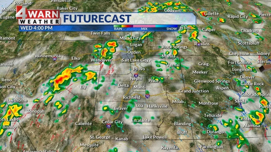
Our area of high pressure will push east towards the Four Corners and while it will usher in above average temperatures, it could also pull far enough east to open the door for an uptick in monsoon moisture. With more moisture potential and high heat, parts of the state could see the potential of isolated thunderstorms. Right now, it looks like the western side of the state and southern Utah have the best chance for a pop up storm today, but storm potential rises for the latter half of the work week.
By Thursday, isolated thunderstorm potential rises and some of these storms could have erratic outflow winds reaching 50 mph. Lightning will also be embedded within these storms with relatively little precipitation reaching the ground, so new fires could spark up.
Increasing clouds will allow temperatures to cool slightly back into the low to mid 90s across northern Utah, and near 100 for SW Utah through the upcoming weekend, which will be close to seasonal norms.
We’ll keep you updated on the latest developments in our 4Warn forecast both on-air and online, we are Good4Utah!
Peak Wasatch Front Heating
Extreme Heat Warning Glen Canyon
Red Flag Warnings for Wasatch Mtns at noon
Triple digit potential today for SLC
Fire Weather Watch for E. Utah Thursday
Isolated storm potential Thurs/Fri/Sat
Increasing moisture potential with high on the move
Drier air by end of the weekend
Latest headlines:
Copyright 2025 Nexstar Media, Inc. All rights reserved. This material may not be published, broadcast, rewritten, or redistributed.
For the latest news, weather, sports, and streaming video, head to ABC4 Utah.


Comments