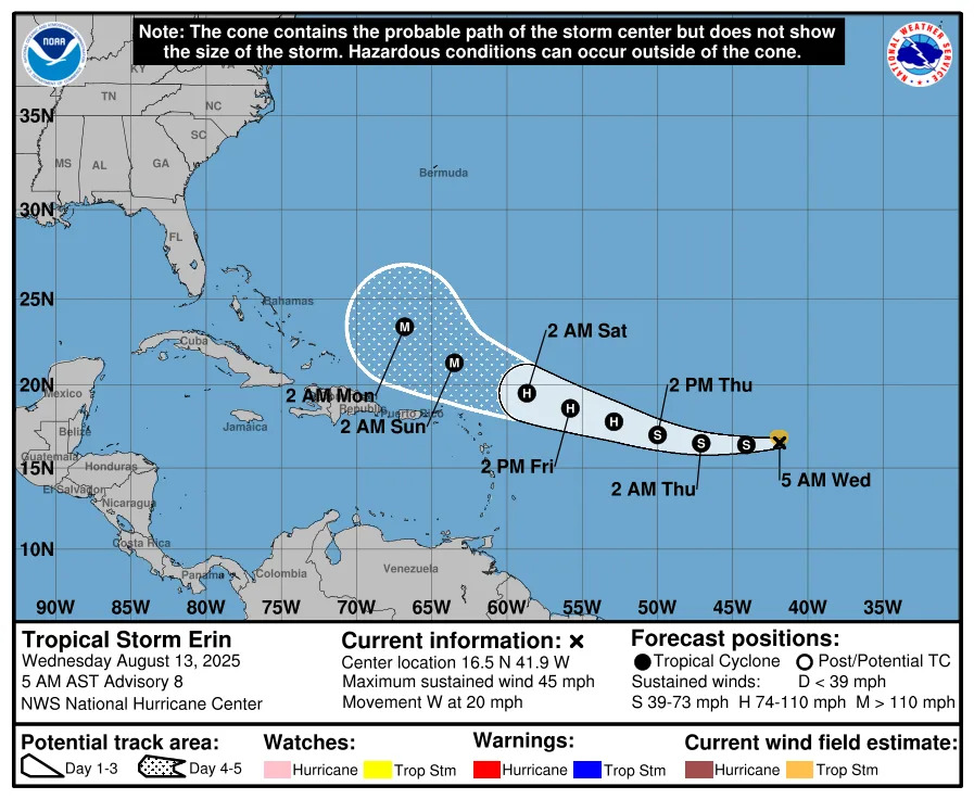
Tropical Storm Erin took a westward shift as it is expected to gain strength and become a hurricane by Aug. 14 or Aug. 15.
The National Hurricane Service is predicting it could become a Category 3 hurricane, with maximum sustained winds of at least 111 mph, by Aug. 17. Originally, the storm was on a path that would take it parallel to the coast, but it’s since shifted a bit to the west.
It’s still too early to tell what direction it will take over the next week. However, forecasters are encouraging residents in Puerto Rico, the Virgin Islands and northern Leeward Islands to closely monitor Erin,
"There is even greater uncertainty in what impacts might occur in portions of the Greater Antilles, the Bahamas, the east coast of the United States, and Bermuda next week," the National Hurricane Center said.
Gov. Ron DeSantis also is monitoring the storm.
"Models for Hurricane Erin currently have it turning north and staying far away from Florida,” DeSantis said. “We continue to monitor for any shifts."
Does Brevard need to prepare for Erin to hit as a hurricane?
At the very least, Space Coast residents will likely experience rough surf and an increase in rip currents from Erin.
“Any stronger storm that occurs over the waters will be capable of gusty winds, lightning strikes, heavy downpours, and briefly higher seas,” according to the National Weather Service in Melbourne.
Erin is the fifth named storm of the season and formed earlier than the historic average of Aug. 22. The average date for the first hurricane is Aug. 11, and the first major hurricane typically does not occur until Sept. 1, according to AccuWeather.
Officials advise this is a good time to stock up on hurricane supplies to be prepared for an impending storms.
Items to include in a hurricane supply kit include:
Water, one gallon for each person per day
Don't like or drink water? Don't buy it. Get what you like to drink but remember that without power, you should be able to drink it warm.
Save money by filling pitchers with tap water. You do not need to buy bottled water.
Non-perishable food
Look for items such as canned fruit, vegetables, and meat; along with cereal, peanut butter, jerky, protein bars and crackers.
Take stock of what you already have in your kitchen and put some in your emergency box if you can. Buying things on BOGO? Good for you; use one now and put the other in your kit.
Don't forget a manual can opener.
Two-week supply of medications
If a state of emergency is declared, pharmacists may dispense up to a 30-day supply of maintenance medication for a chronic condition.
Batteries
From portable fans to flashlights, these will come in handy.
Flashlight
Much safer than candles.
Cash, in case the power is out and ATMs are not working.
A go-bag with essential supplies in case you need to leave quickly
Portable cellphone chargers
Battery-operated radio
List of emergency phone numbers, including those for family members
Copy of your insurance policy
This doesn't technically go in a kit but be sure to keep your car's gas tank full.
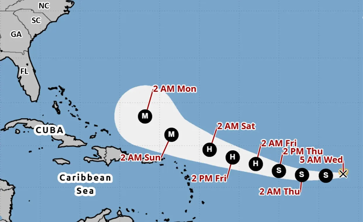
Spaghetti models for Tropical Storm Erin. Where is it headed?
Special note about spaghetti models: Illustrations include an array of forecast tools and models, and not all are created equal. The hurricane center uses only the top four or five highest performing models to help make its forecasts.
Hurricane Erin previously impacted Brevard 30 years ago
In 1995, a different Hurricane Erin made landfall near Vero Beach and brought significant wind and rain to the Space Coast.
Evacuations were ordered for the barrier islands and the storm produced tornadoes and flooding rain across much of the county. At the time some residents took to boats to navigate flooded roadways.
The Federal Emergency Management Agency-financed a project to improve stormwater strategy and prevent major flooding like that again.
Spitzer is a Trending Reporter. She can be reached at [email protected].
This article originally appeared on Florida Today: Latest on Tropical Storm Erin's shift. Will it come to Brevard?


Comments