Tropical Storm Erin is starting to strengthen as it continues its westward path across the Atlantic, according to the latest advisory from the National Hurricane Center.
Erin is expected to become a hurricane Friday, Aug. 15 and a major hurricane by Sunday morning. A major hurricane is a Category 3 or stronger storm with maximum sustained winds of at least 111 mph.
➤ Weather alerts via text: Sign up to get updates about current storms and weather events by location
The current forecast calls for Erin's winds to increase to 125 mph within five days, making it a strong Category 3 storm. A Category 4 storm has maximum sustained winds of at least 130 mph.
Erin is expected to turn north at some point, staying away from Florida and the east coast of the United States.
However, there the "risk of dangerous surf and rip currents across the western Atlantic basin next week is increasing," the National Hurricane Center said.
The fifth-named storm of the Atlantic hurricane season, Erin formed on Aug. 11, earlier than the historical average of Aug. 22.
➤ Hurricane drama vs. data: Why Erin is a miniscule threat to Florida, U.S. east coast
Tropical Storm Erin update, path
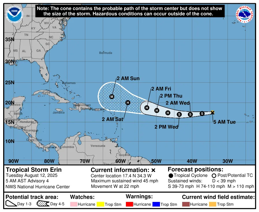
Special note on the NHC cone: The forecast track shows the most likely path of the center of the storm. It does not illustrate the full width of the storm or its impacts, and the center of the storm is likely to travel outside the cone up to 33% of the time.
Location: 990 miles east of the northern Leeward Islands; 2,163 miles east of West Palm Beach
Maximum sustained winds: 50 mph
Movement: west at 17 mph
Pressure: 1,002 mb
Next advisory: 11 a.m. ET
When will Tropical Storm Erin become a hurricane?
Tropical Storm Erin is expected to become a hurricane Friday, Aug. 15.
"Significant intensification" is possible Friday and Saturday, and Erin is expected to become a strong Category 3 storm with maximum sustained winds of 125 mph in five days, according to the National Hurricane Center.
➤ Hurricane drama vs. data: Why Erin is a miniscule threat to Florida, U.S. east coast
Spaghetti models for Tropical Storm Erin. Where is the storm going?
Special note about spaghetti models: Illustrations include an array of forecast tools and models, and not all are created equal. The hurricane center uses only the top four or five highest performing models to help make its forecasts.
Is there a hurricane coming to Florida?
No. Erin should gradually turn more west-northwestward Thursday night, with that path continuing into the weekend.
On that path, Erin would remain over open water and away from Florida and the U.S.
Remember, forecasts can change so it's always best to be prepared.
What impacts could Tropical Storm Erin have on Florida?
"There is still a greater than normal uncertainty about what impacts Erin may bring to portions of the Bahamas, the east coast of the United States, and Bermuda in the long range," the National Hurricane Center said.
However, "the risk of dangerous surf and rip currents across the western Atlantic basin next week is increasing."
How strong is Tropical Storm Erin and where could it go? See the scenarios
At 5 a.m., the center of Tropical Storm Erin was located near latitude 16.3 North, longitude 48.2 West.
Erin is moving toward the west near 17 mph. This general motion is expected to continue today, with a west-northwestward motion beginning tonight and continuing into the weekend.
On the forecast track, the center of Erin is likely to move near or just north of the northern Leeward Islands over the weekend.
Maximum sustained winds are near 50 mph, with higher gusts. Tropical-storm-force winds extend outward up to 60 miles from the center.
Gradual strengthening is forecast during the next day or so, with more significant intensification possible on Friday and Saturday.
Key messages from the National Hurricane Center: What you need to know about Tropical Storm Erin
Swells generated by Erin will begin affecting portions of the northern Leeward Islands, the Virgin Islands and Puerto Rico by this weekend. These swells are likely to cause life-threatening surf and rip current conditions.
Erin is beginning to strengthen and is expected to become a hurricane Aug. 14.
"There continues to be confidence that Erin will be a large and powerful hurricane over the southwestern Atlantic Ocean this weekend."
There is still a greater than normal uncertainty about what impacts Erin may bring to portions of the Bahamas, the east coast of the United States, and Bermuda in the long range.
Locally heavy rainfall, high surf and rip currents, and tropical-storm force winds could occur in portions of the northern Leeward Islands, the Virgin Islands, and Puerto Rico this weekend as the core of Erin passes north of those islands.
The risk of dangerous surf and rip currents across the western Atlantic basin next week is increasing.
Current forecast: How strong could Tropical Storm Erin get?
At 5 a.m.: 50 mph
12 hours: 60 mph
24 hours: 65 mph
36 hours: 80 mph
48 hours: 100 mph
60 hours: 110 mph
72 hours: 115 mph
96 hours: 120 mph
120 hours: 125 mph
Interactive map: What tropical storms, hurricanes have impacted your area in the past?
Stay informed. Get weather alerts via text
What's next?
We will update our tropical weather coverage daily.
Download your local site's app to ensure you're always connected to the news. And look for our special subscription offers here.
This article originally appeared on Naples Daily News: Tropical Storm Erin tracker, spaghetti models. Florida impacts


Comments