Erin intensifies in Atlantic while Gulf moisture sets stage for Minnesota-Wisconsin deluge originally appeared on Bring Me The News.
Unlike many recent years, much of the summer has been pretty quiet in the Atlantic basin for tropical storms. Just last year, Hurricane Beryl was one of only two named storms to reach major hurricane status in the month of July, along with Emily in 2005.
As recently as 2023, we had the fifth most named storms on record, with 20 tropical storms. The 2020 season saw the most named storms ever recorded at 30. In 2025—at least so far—it’s been relatively quiet.

August and September are the peak months for the Atlantic hurricane season. This is when the waters of the Atlantic, Caribbean, and Gulf are at their warmest after a long summer. It’s also when wind shear is at a minimum—good for creating supercell thunderstorms in the Plains, but bad for stopping tropical storm systems.
While Beryl’s formation in June and early July seemed ominous for the season, things slowed down in mid-summer. We reached “E” in the alphabet last year at roughly the same time as this year (Ernesto became a tropical storm on August 12).
Erin officially became a tropical storm on August 11 this year. It’s forecast to become a hurricane early Friday morning. A Category 1 hurricane is defined by sustained winds around the center eyewall of at least 74 mph.
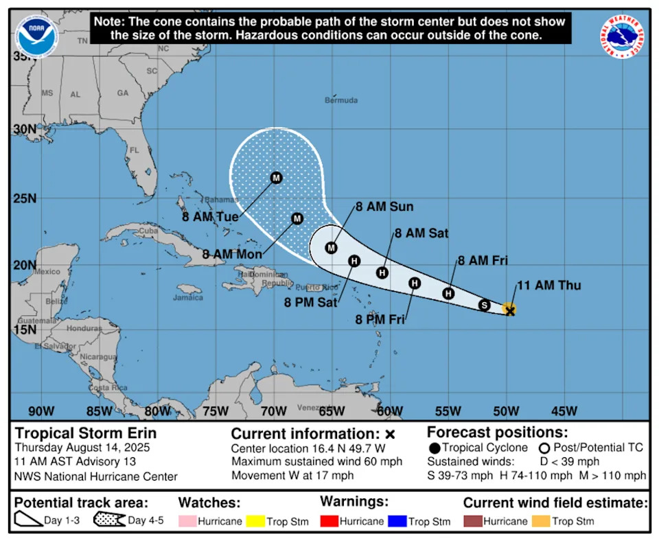
Erin is forecast to reach major hurricane status—Category 3 or higher, with maximum sustained winds of 111 mph or greater—by Saturday night or early Sunday.
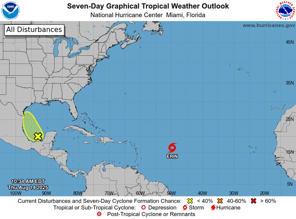
NOAA’s National Hurricane Center (NHC) is also monitoring an area just west of the Yucatán Peninsula in the western Gulf, off the coast of Texas, for potential tropical storm development. They place the odds at 20% for formation within the next seven days.
Both the Atlantic Basin and the Gulf are seeing sea surface temperature anomalies (SSTs) warmer than normal. Warm ocean water is the key ingredient for hurricanes, especially rapidly intensifying storms.
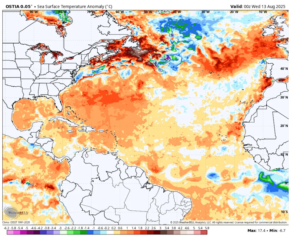
The good news this year is that the waters of the Atlantic aren’t as extraordinarily warm as in the last two years. This is mainly because we’re not in an El Niño pattern, when global air and ocean temperatures tend to be warmer on average. Our oceans are still very warm, though—a direct result of climate change.
In the Atlantic’s main tropical development area, waters are warmer than normal but far from the record levels of the last two years.
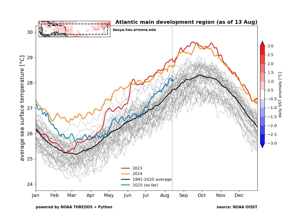
The red and orange lines on the chart represent 2023 (the warmest year on record) and 2024 (the second warmest), respectively. The blue line for 2025 is about 2°F cooler than those years.
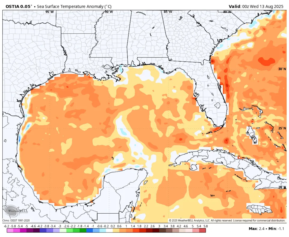
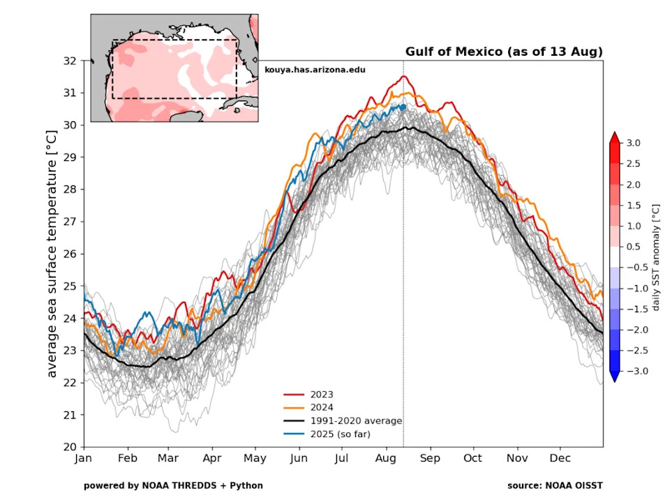
A similar story is playing out in the Gulf. Surface water temperatures are above normal but not at the record pace of 2023 and 2024. They’re generally 1–2°F cooler than those years, but there’s still plenty of energy in the Gulf to generate and sustain hurricanes.
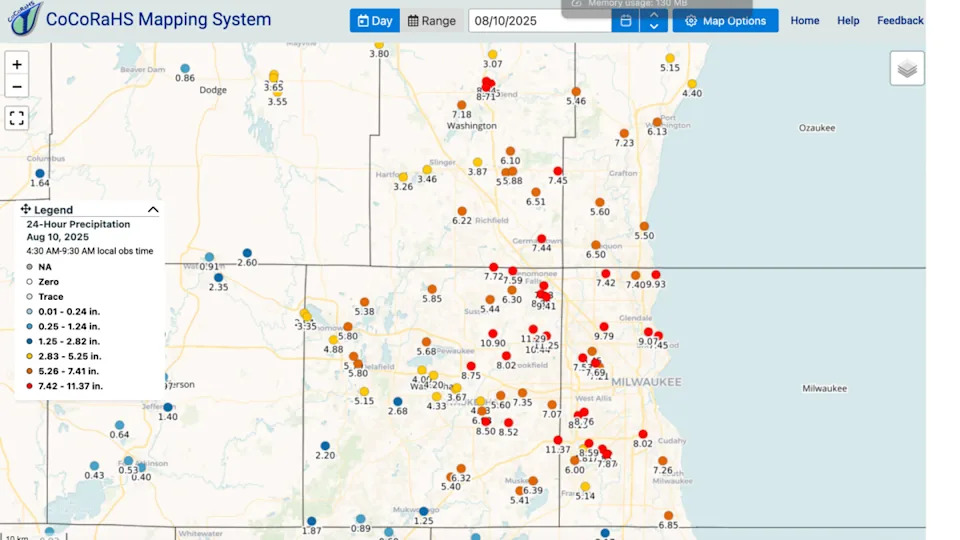
Much of the central U.S. and Midwest has also seen a very wet summer, thanks in large part to high dew points originating from the Gulf. Last weekend, the Milwaukee area was inundated with a record 10 to 12 inches of rainfall.
Those amounts are something you’d expect from a tropical storm or hurricane, not typical Midwest thunderstorms. Extreme rainfall events are becoming more common in the central and eastern U.S. due to climate change.
Somewhere in Minnesota or Wisconsin could see very heavy rainfall over the next several days as a stalled frontal boundary taps into high dew points and upper-level disturbances passing through.
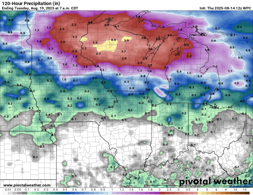
While hopefully not a repeat of last weekend (10 inches of rain is nearly impossible to forecast in the Midwest), several inches of multi-day rainfall totals are possible.
Precipitable water content—the amount of water available if condensed from the atmospheric column—is forecast to be two to three times normal values for mid-August.
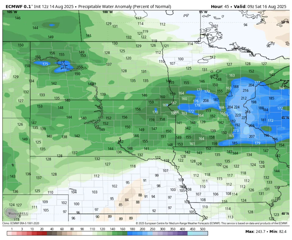
That kind of water content brings the potential for extreme rainfall amounts. The setup involving the frontal boundary, high dew points, and upper-level patterns will need to be closely monitored into the weekend for heavy rain potential.
This story was originally reported by Bring Me The News on Aug 14, 2025, where it first appeared.


Comments