In a rush? Get an abbreviated, text view of what's happening with Hurricane Erin.
Hurricane Erin is bringing coastal flooding to North Carolina and mid-Atlantic beaches this morning as it makes its closest approach to the United States, according to the 8 a.m. Thursday, Aug. 21, advisory from the National Hurricane Center.
Erin is a Category 2 hurricane with maximum sustained winds of 105 mph.
➤Hurricane Erin to bring 'powerful' 20-foot waves along East Coast
➤ Weather alerts via text: Sign up to get updates about current storms and weather events by location
Officials continue to warn beachgoers to stay out of the water due to dangerous surf and life-threatening rip currents.
In Florida, Erin's impacts continued to be felt along the coast, with breakers expected up to 8 feet in Northeast Florida and up to 7 feet along the east central coast, according to the National Weather Service.
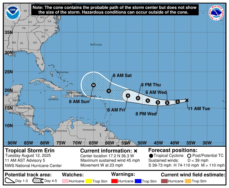
Hurricane Erin projected path. See current location
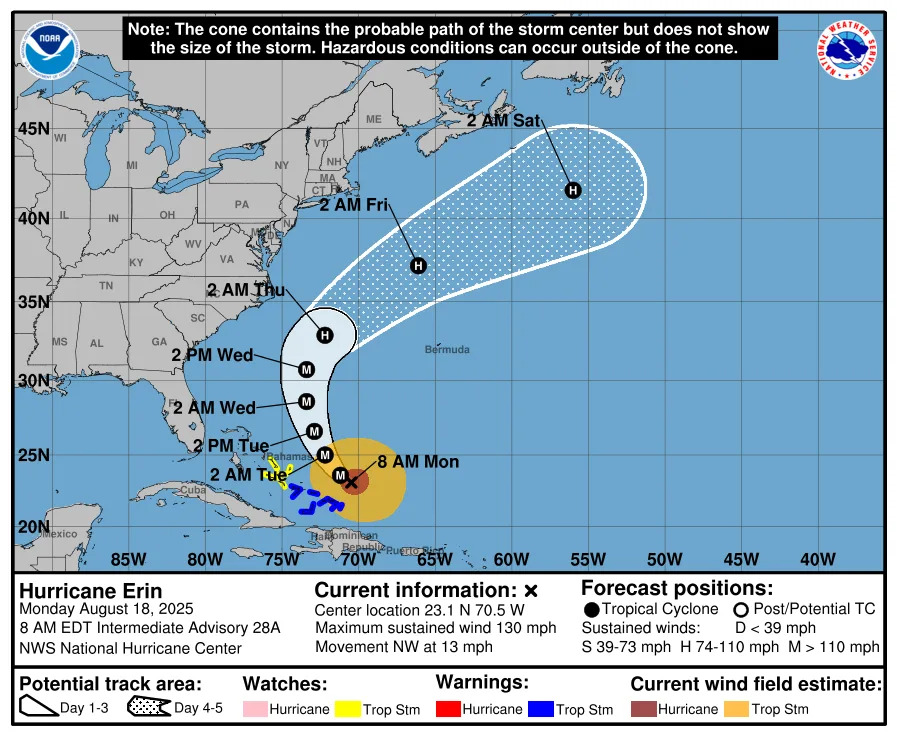
Special note on the NHC cone: The forecast track shows the most likely path of the center of the storm. It does not illustrate the full width of the storm or its impacts, and the center of the storm is likely to travel outside the cone up to 33% of the time.
Location: 210 miles east of Cape Hatteras, North Carolina; 440 miles west-northwest of Bermuda; and 444 miles east of Jacksonville
Maximum sustained winds: 105 mph
Movement: north-northeast at 17 mph
Pressure: 945 mb
Next advisory: 11 a.m. ET
North Carolina, mid-Atlantic feeling impacts from Hurricane Erin. See watches, warnings
The National Weather Service in Morehead City, North Carolina, warned residents about 7 a.m. that Erin was making its closest approach to the coast, about 200 miles east-southeast of Cape Hatteras. Tropical-storm-force winds were expected Thursday morning on the Outer Banks.
"Significant impacts are underway. Coastal flooding, storm surge and overwash will peak today into this evening. Impacts will last through Friday (Aug. 22) in some spots.
"This will be a long duration event for the Outer Banks, impacting Highway 12 through late week."
Waves up to 20 feet in the surf zone were expected to bring "extensive beach erosion."
Several watches associated with Erin have been issued for areas along the east coast:
Storm surge warning: Cape Lookout to Duck, North Carolina
Tropical storm warning: Beaufort Inlet, North Carolina to Chincoteague, Virginia, including Pamlico and Albemarle Sounds
➤ NC 12 may be 'impassable' for days due to Hurricane Erin over wash. See evacuation routes
See peak storm surge forecast from Hurricane Erin
Spaghetti models for Hurricane Erin. See projected path
Special note about spaghetti models: Illustrations include an array of forecast tools and models, and not all are created equal. The hurricane center uses only the top four or five highest performing models to help make its forecasts.
What impacts is Hurricane Erin having on Florida Aug. 21?
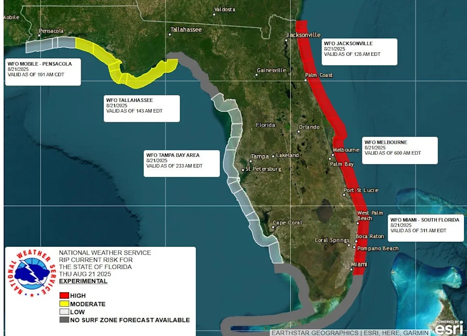
Erin continues to bring frequent and life-threatening rip currents to Northeast Florida beaches. Breakers could be 5 to 8 feet.
Along east central Florida beaches, life-threatening rip currents continue Thursday, along with 5-7 foot breakers.
How strong is Hurricane Erin and where is it going now?
At 8 a.m., the center of Hurricane Erin was located near latitude 34.8 North, longitude 71.8 West.
Erin is moving toward the north-northeast near 17 mph. A turn toward the northeast with an increase in forward speed is expected later today, followed by an acceleration toward the east-northeast Friday into the weekend.
On the forecast track, the center of Erin will move over the western Atlantic between the U.S. east coast and Bermuda through early Friday, and then pass south of Atlantic Canada Friday and Saturday.
Maximum sustained winds are near 105 mph, with higher gusts.
Gradual weakening is forecast during the next couple of days. Erin is expected to become post-tropical on Saturday.
Erin is a large hurricane. Hurricane-force winds extend outward up to 105 miles from the center and tropical-storm-force winds extend outward up to 320 miles.
Watches and warnings issued for Hurricane Erin
A storm surge warning is in effect for:
Cape Lookout to Duck, North Carolina
A tropical storm warning is in effect for:
Beaufort Inlet, North Carolina to Chincoteague, Virginia, including Pamlico and Albemarle Sounds
A tropical storm watch is in effect for:
Bermuda
Hazards affecting land from Hurricane Erin
Wind: Tropical storm conditions will continue to affect portions of the North Carolina Outer Banks and the Virginia coastline for the next several hours. Elsewhere along the mid-Atlantic and southern New England coast, wind gusts to tropical storm force are likely today through early Friday. Tropical storm conditions are possible on Bermuda this afternoon through early Friday. Gusts to gale force are possible along portions of the coast of Nova Scotia on Friday and the Avalon Peninsula of Newfoundland on Saturday.
Surf: Swells generated by Erin will affect the Bahamas, Bermuda, the east coast of the United States, and Atlantic Canada during the next several days. These rough ocean conditions are expected to cause life-threatening surf and rip currents.
Storm surge: The combination of a dangerous storm surge and the tide will cause normally dry areas near the coast to be flooded by rising waters moving inland from the shoreline. The water could reach the following heights above ground somewhere in the indicated areas if the peak surge occurs at the time of high tide:
Cape Lookout to Duck, North Carolina: 2 to 4 feet
The deepest water will occur along the immediate coast where the surge will be accompanied by large and dangerous waves. Surge-related flooding depends on the relative timing of the surge and the tidal cycle, and can vary greatly over short distances.
Key messages from the National Hurricane Center: What you need to know about Hurricane Erin
Erin will continue to produce life-threatening surf and rip currents along the beaches of the Bahamas, much of the east coast of the U.S., Bermuda, and Atlantic Canada during the next several days. Beachgoers in those areas should follow advice from lifeguards, local authorities, and beach warning flags.
Storm surge flooding and tropical storm conditions will continue on the North Carolina Outer Banks today. The storm surge will be accompanied by large waves, leading to significant beach erosion and overwash, making some roads impassible.
Tropical storm conditions are expected today along the Virginia coast. Wind gusts to tropical storm force are likely along portions of the remainder of the U.S. Mid-Atlantic and southern New England coasts today through early Friday.
Tropical storm conditions are possible on Bermuda this afternoon through early Friday. Gusts to gale force are possible along the coast of Nova Scotia on Friday and the Avalon Peninsula of Newfoundland on Saturday.
Current forecast: How strong could Hurricane Erin get?
At 8 a.m.: 105mph
12 hours: 105 mph
24 hours: 100 mph
36 hours: 100 mph
48 hours: 85 mph
60 hours: 75 mph; post-tropical, extratropical
72 hours: 70 mph; post-tropical, extratropical
96 hours: 65 mph; post-tropical, extratropical
120 hours: 50 mph; post-tropical, extratropical
Hurricane categories: Saffir-Simpson Hurricane Wind Scale
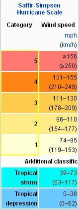
Category 1 hurricane: 74-95 mph
Category 2 hurricane: 96-110 mph
Category 3 hurricane: 111-129 mph
Category 4 hurricane: 130-156 mph
Category 5 hurricane: 157 mph or higher
Stay informed. Get weather alerts via text
What's next?
We will update our tropical weather coverage daily.
Download your local site's app to ensure you're always connected to the news. And look for our special subscription offers here.
This article originally appeared on Treasure Coast Newspapers: Hurricane Erin US, Florida impacts. Latest forecast path, models


Comments